
The Trail
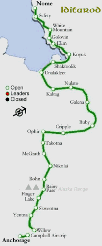 I just realized I haven’t provided the trail distances between checkpoints.
Willow – Start
Yentna Station – 52 miles [84 km]
Skwentna – 34 miles [55 km]
Finger Lake – 45 miles [72 km]
Rainy Pass – 30 miles [48 km]
Rohn – 48 miles [77 km]
Nikolai – 75 miles [121 km]
McGrath – 54 miles [87 km]
Takotna – 18 miles [29 km]
Ophir – 25 miles [40 km]
Cripple – 59 miles [95 km]
Ruby – 112 miles [180 km]
Galena – 52 miles [84 km]
Nulato – 52 miles [84 km]
Kaltag – 42 miles [68 km]
Unalakleet – 90 miles [145 km]
Shaktoolik – 42 miles [68 km]
Koyuk – 48 miles [77 km]
Elim – 48 miles [77 km]
Golovin – 28 miles [45 km]
White Mountain – 18 miles [29 km]
Safety – 55 miles [88 km]
Nome – 22 miles [35 km]
The distance is from the previous checkpoint. Some teams in the early going will travel at 12 mph [20kph] or better with all 16 dogs eager to go.


4 comments
Hi Brian: Good to see your updates again this year!
Question for you: Looks like the first musher has checked in at Finger Lake. I seem to remember hearing the stretch from Finger Lake through Rainy Pass is considered the most treacherous. Have I got that right?
This is the nastiest part of the trail coming up, Juanita. There is a switchback descent into the gorge, the climb up the mountains to the pass, which has its own weather, then down the other side in Rohn. Between Rohn and Nikolai you have the Burn, which is a fire destroyed area with second growth filled with stumps and small trees. Because of the new growth trees the Burn also attracts moose, and moose don’t like dogs.
This is definitely the nastiest part of the trail coming up.
Thanks for the info, Bryan (sorry about the spelling prior 🙂 It would have been only fair for you to mangle my name as well, but you were a gentleman about it!
Speaking of the weather, I went to the Weather Underground site and noticed that Finger Lake area is getting some high winds. Looks like gusts up to 50 mph! That can’t be good…
Wind chills, and the dogs don’t like it. One of the things the best lead dogs have is an ability to ignore the wind and can get the team to go along with it. The dogs will naturally respond by laying down and covering their noses with their tails until the wind dies. The mountains concentrate the winds, which produce the Santa Ana’s in Southern California and the gusty winds in any mountainous area. If there were more snow, it would cause white outs, which would be very dangerous on the trail ahead. If they have gusty winds at Finger Lake, Rainy Pass is going to be a real problem.
That was a big problem for people around the Norton Sound last year – the dogs wouldn’t move.
This is ‘Net – spelling is optional. 😉