
No One Could Have Predicted
Those are real hurricanes, which shows why predicting where they are going and how they are going to get there is as much art, as science at the moment.
August 28, 2010 Comments Off on No One Could Have Predicted
Five Years Ago
On this date five years ago I was monitoring four weather sites, the local radio, and the NOAA radio for news about a storm in the Gulf – Katrina.
We had already been smacked by Dennis, which was a bigger mess than necessary because thanks to stalling by FEMA, we hadn’t managed to clean up from Ivan the year before, and now we were faced with another one.
On the 25th Mustang Bobby live-blogged Katrina coming ashore in South Florida [until his power failed at 8:15] as a Cat 1 hurricane after popping up the Bahamas, and the passage over the Everglades hadn’t weakened the storm appreciably. When it came into the Gulf the water was hot, in the 80s, so it had plenty of energy to build on and a minimum of wind sheer.
At around 1PM on the 28th Katrina was about 300 miles South-Southwest of me when the winds peaked at 175 mph and the pressure dropped to 902 mb, moving into the list of the five most powerful storms ever seen in the Atlantic Basin.
Having reached its maximum strength it began its relentless march to the North, building up a huge storm surge in front of it. If it had come at angle some of the surge might have slid off to the side, but couldn’t happen on the path that Katrina took. That’s why, even though we were about 200 miles East of the landfall, we had an 8-foot surge.
Katrina’s winds dropped to Category 3 strength before landfall, but the massive surge didn’t diminish at all. Waveland, Mississippi wasn’t blown away, it was washed away by the surge.
August 28, 2010 Comments Off on Five Years Ago
Déjà Vu
If you watch tropical events for an extended period one of the problems is that they reuse names every six years. This year they are using most of the names that were used in 2004, which was a very busy year indeed.
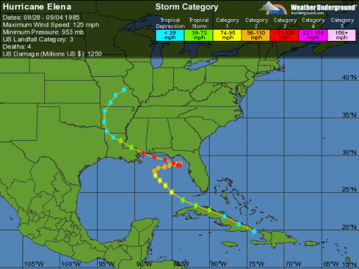
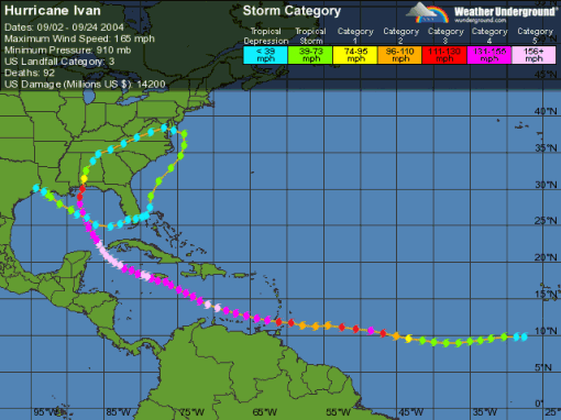
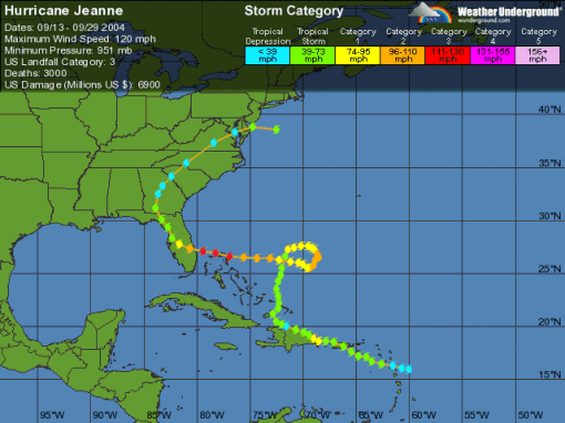
There are four names that are not being reused: Charley, Frances, Ivan, and Jeanne. If a storm is bad enough, the name is retired. Those four and Tropical Storm Bonnie hit Florida that year and we got the first hint that FEMA was broken. The Bush brothers talked a good game, it was an election year after all, but after the election the people affected were ignored.
We got all the way through to Otto in 2004, but few people realized that it was just a scrimmage, and the real game would be 2005. We were too busy trying to clean up the mess so we could rebuild, and neither FEMA or the insurance companies were making it easy.
August 28, 2010 Comments Off on Déjà Vu
Tropical Storm Earl – Day 4
 Position: 16.6N 55.4W [10 PM CDT 0300 UTC].
Movement: West [280°] near 20 mph [32 kph].
Maximum sustained winds: 65 mph [100 kph].
Wind Gusts: 75 mph [115 kph].
Tropical Storm Wind Radius: 160 miles [260 km].
Minimum central pressure: 989 mb ↓.
Currently about 520 miles [ 835 km] East of the Leeward Islands.
A Hurricane Warning is in effect for Saint Martin, Saint Barthelemy, Antigua, Barbuda, Montserrat, St. Kitts, Nevis, Anguilla, St. Maarten, Saba, and St. Eustatius.
A Hurricane Watch is in effect for British Virgin Islands, US Virgin Islands, and for the islands of Culebra and Vieques.
Earl strengthened overnight and is expected to curve towards the Northwest.
Here’s the link for NOAA’s latest satellite images.
[For the latest information click on the storm symbol, or go to the CATEGORIES drop-down box below the CALENDAR and select “Hurricanes” for all of the posts related to storms on this site.]
August 28, 2010 Comments Off on Tropical Storm Earl – Day 4
Hurricane Danielle – Day 8
 Position: 31.5N 58.8W [10 PM CDT 0300 UTC].
Movement: North-Northeast [030°] near 20 mph [32 kph].
Maximum sustained winds: 105 mph [165 kph].
Wind Gusts: 125 mph [195 kph].
Tropical Storm Wind Radius: 185 miles [295 km].
Hurricane Wind Radius: 70 miles [110 km].
Minimum central pressure: 958 mb ↓.
Currently about 1095 miles [1760 km] South-Southwest of Cape Race, Newfoundland.
The Tropical Storm Watch for Bermuda has been canceled.
Danielle ran into stronger wind shear and a change of steering overnight. The storm dropped to a category 2 and turned away from its path towards Bermuda.
Here’s the link for NOAA’s latest satellite images.
[For the latest information click on the storm symbol, or go to the CATEGORIES drop-down box below the CALENDAR and select “Hurricanes” for all of the posts related to storms on this site.]
August 28, 2010 Comments Off on Hurricane Danielle – Day 8


