
Posts from — August 2012
I Need A Break
So, as usual, I prepared to download the pictures from my camera to select one for Cat Blogging and some others on how the roses are doing for my Mother. This is a normal Thursday evening activity. nothing out of the ordinary.
I got the camera and grabbed the cable off the hook. The camera cable is easy to spot because it has a ferrite coil built in.
I plugged the standard USB plug into the computer and the mini-plug into the camera and nothing happened. The camera should automatically power on and start charging when the cable is plugged in to a USB port and the computer should load the file transfer program and beep.
I have three USB ports on the front of the computer and none of them worked. OK, it’s a new computer and things die on new computers, so I decided to switch to the Win XP machine.
Both Win boxes are plugged into the same UPS so I powered down the Win 7 box and powered on the XP box. [Aside: Win boxes should come with the Carly Simon greatest hits album, because Anticipation is so appropriate for the boot cycle and the same could be said about You’re So Vain applied to Bill.]
When the XP decided to function I got the same non-response, so I decided that either the cable or the camera were broken, and nothing could be done until the morning.
I’m wrapping up the cable to put it aside and saw there were two cables, not one, and I had been plugging one into the computer and the other into the camera. I did this with a total of five USB ports on two different computers.
I need a break…
August 31, 2012 39 Comments
Hurricane Kirk – Day 4
 Position: 33.9N 49.5W [10PM CDT 0300 UTC].
Movement: North-Northeast [015°] near 16 mph [26 kph].
Maximum sustained winds: 80 mph [130 kph].
Wind Gusts: 95 mph [150 kph].
Tropical Storm Wind Radius: 70 miles [110 km].
Hurricane Wind Radius: 15 miles [ 30 km].
Minimum central pressure: 988 mb ↑.
Currently about 905 miles [1455 km] South-Southeast of Cape Race, Newfoundland.
Here’s the link for NOAA’s latest satellite images.
[For the latest information click on the storm symbol, or go to the CATEGORIES drop-down box below the CALENDAR and select “Hurricanes” for all of the posts related to storms on this site.]
August 31, 2012 Comments Off on Hurricane Kirk – Day 4
Tropical Storm Leslie – Day 2
 Position: 17.4N 52.8W [10PM CDT 0300 UTC].
Movement: West-Northwest [295°] near 21 mph [33 kph].
Maximum sustained winds: 65 mph [100 kph].
Wind Gusts: 80 mph [130 kph].
Tropical Storm Wind Radius: 90 miles [150 km].
Minimum central pressure: 999 mb.
Currently about 595 miles [ 955 km] East of the Leeward Islands.
Here’s the link for NOAA’s latest satellite images.
[For the latest information click on the storm symbol, or go to the CATEGORIES drop-down box below the CALENDAR and select “Hurricanes” for all of the posts related to storms on this site.]
August 31, 2012 Comments Off on Tropical Storm Leslie – Day 2
Friday Cat Blogging
Mini-Sox
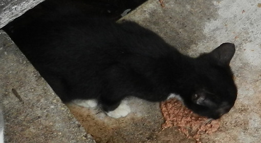
Nom…Nom…Nom
[Editor: This the first picture I’ve been able to get of this kitten who is about ten weeks old. It is the first tuxedo among the ferals in years. The marking pattern is shared with Sox, but was also the pattern of this kitten’s grandmother, Tonto, except that she was blue and white. The kitten is a ‘rocket’ and is rarely stationary. This is the first time it has showed up to eat while I was still in the area.]
August 31, 2012 8 Comments
The ‘Fun’ Never Ends
The BBC has a story on the need to dump water from a dam in Mississippi on the Tangipahoa River because the structure was damaged by the storm and may collapse if the pressure isn’t released.
This has required Louisiana officials to begin evacuating people downstream because of the flooding that will result from the release.
This type of problem is occurring in several places because local flood control measures [dams and levees] are being stressed by the storm surge and the rain runoff.
On the plus side, the rains will ameliorate the drought conditions and fill lakes and reservoirs that are running dry, but it won’t end the drought unless the weather pattern changes and the normal rains return.
August 30, 2012 Comments Off on The ‘Fun’ Never Ends
Hurricane Kirk – Day 3
 Position: 29.0N 50.7W [10PM CDT 0300 UTC].
Movement: North-Northwest [335°] near 12 mph [19 kph].
Maximum sustained winds: 100 mph [160 kph].
Wind Gusts: 115 mph [185 kph].
Tropical Storm Wind Radius: 70 miles [110 km].
Hurricane Wind Radius: 15 miles [ 30 km].
Minimum central pressure: 980 mb ↓.
Currently about 870 miles [1395 km] East-Northeast of Bermuda.
Here’s the link for NOAA’s latest satellite images.
[For the latest information click on the storm symbol, or go to the CATEGORIES drop-down box below the CALENDAR and select “Hurricanes” for all of the posts related to storms on this site.]
August 30, 2012 Comments Off on Hurricane Kirk – Day 3
Tropical Depression Isaac – Day 10
 Position: 32.7N 92.6W [ 4PM CDT 2100 UTC].
Movement: North-Northwest [335°] near 12 mph [19 kph].
Maximum sustained winds: 35 mph [ 55 kph].
Wind Gusts: 50 mph [ 80 kph].
Minimum central pressure: 995 mb ↑.
Update 4PM CDT: although Isaac has been downgraded to a tropical depression and the tropical weather alerts have been cancelled it is still producing coastal surge, heavy rains, tornadoes, and gusty winds along the Gulf Coast.
The 4PM advisory was the last by the NHC. Further reporting will be coming from the Hydrometeorological Prediction Center [HPC].
Here’s the link for NOAA’s latest satellite images.
[For the latest information click on the storm symbol, or go to the CATEGORIES drop-down box below the CALENDAR and select “Hurricanes” for all of the posts related to storms on this site.]
August 30, 2012 2 Comments
Tropical Storm Leslie
Position: 14.7N 46.8W [10PM CDT 0300 UTC].
Movement: West [280°] near 18 mph [30 kph].
Maximum sustained winds: 50 mph [ 80 kph].
Wind Gusts: 65 mph [100 kph].
Tropical Storm Wind Radius: 45 miles [ 75 km].
Minimum central pressure: 1002 mb ↓.
Currently about 1010 miles [1625 km] East of the Leeward Islands.
Here’s the link for NOAA’s latest satellite images.
[For the latest information click on the storm symbol, or go to the CATEGORIES drop-down box below the CALENDAR and select “Hurricanes” for all of the posts related to storms on this site.]
August 30, 2012 Comments Off on Tropical Storm Leslie
Kids Still Think In Australia
The ABC has a nice story about an elementary school student: Eureka moment for Fox in the henhouse
A year five student who made a discovery about a new kind of link between protein and eggs was among those honoured at last night’s Eureka Prize ceremony for excellence in science.
Inspiration can come from unexpected places, and for Ignatius Fox it came when his chickens suddenly laid bigger eggs after breaking into the worm farm.
“So we thought that the worms would give protein to them so we tried giving protein to give the big eggs and it worked,” Ignatius said.
…Dr Karl Kruszelnicki, who presented the award, thinks the student’s insight puts him ahead of many adults.
“So we’ve got an 11-year-old person who’s made an observation, accidental observation, then formed a hypothesis and then tested it out as opposed to certain radio jocks who’ll say, gee, it was warm now and it’s colder tonight, therefore there’s no such thing as global warming,” he said.
This is the scientific method in action – ask the question, formulate an answer, devise a test for your answer. That’s what many US states don’t want schools to teach anymore because it’s ‘controversial’.
[BTW, the headlines at ABC can be better than the stories. Humor, for a given meaning of humor, is not discouraged.]
August 29, 2012 2 Comments
Tropical Storm Kirk – Day 2
Position: 25.9N 48.3W [10PM CDT 0300 UTC].
Movement: West-Northwest [300°] near 9 mph [15 kph].
Maximum sustained winds: 60 mph [ 95 kph].
Wind Gusts: 75 mph [120 kph].
Tropical Storm Wind Radius: 70 miles [110 km].
Minimum central pressure: 1002 mb ↓.
Currently about 1085 miles [1745 km] East-Northeast of the northern Leeward Islands.
Here’s the link for NOAA’s latest satellite images.
[For the latest information click on the storm symbol, or go to the CATEGORIES drop-down box below the CALENDAR and select “Hurricanes” for all of the posts related to storms on this site.]
August 29, 2012 Comments Off on Tropical Storm Kirk – Day 2
Tropical Storm Isaac – Day 9
Position: 30.3N 91.2W [10PM CDT 0300 UTC].
Movement: Northwest [320°] near 6 mph [ 9 kph].
Maximum sustained winds: 60 mph [ 95 kph].
Wind Gusts: 75 mph [120 kph].
Tropical Storm Wind Radius: 175 Miles [280 km].
Minimum central pressure: 980 mb ↑.
Currently about 70 miles [110 km] West-Northwest of New Orleans.
Currently about 15 miles [ 25 km] South of Baton Rouge.
A Tropical Storm Warning is in effect from Cameron, Louisiana to the Alabama-Florida border.
Update 1AM CDT: The eye is over water and it has stalled out. This is not good news for anyone as it prolongs the agony, increases the rainfall, and increases the surge.
Update 7AM CDT: After moving about 40 miles [65 km] early this morning, it has stalled again.
Update 2PM CDT: Downgraded to a Tropical Storm.
Here’s the link for NOAA’s latest satellite images.
[For the latest information click on the storm symbol, or go to the CATEGORIES drop-down box below the CALENDAR and select “Hurricanes” for all of the posts related to storms on this site.]
August 29, 2012 10 Comments
Katrina

It wasn’t the storm, it was the levees.
It wasn’t Nature, it was man.
The Weather Underground’s Hurricane Katrina tracking map.
An animation of the National Hurricane Center’s tracking maps. If you stop the animation and step to frame 13 you will see that they had Katrina coming to my house for a while.
The track on Google map from the Central Florida Hurricane Center so you can see exactly where the storm struck, and it wasn’t New Orleans.
Katrina did have top sustained winds of 175 mph with a pressure of 902 millibars, a Category 5 storm, but that was in the central Gulf of Mexico. It came ashore as a Category 3 hurricane to the East of New Orleans. There was minimal wind damage in the city from the hurricane.
Wikipedia has a nice article on Katrina, without going totally technical on the science behind hurricanes.
August 29, 2012 Comments Off on Katrina
Tropical Storm Kirk
Position: 23.9N 45.0W [10PM CDT 0300 UTC].
Movement: West [280°] near 12 mph [19 kph].
Maximum sustained winds: 45 mph [ 70 kph].
Wind Gusts: 55 mph [ 90 kph].
Tropical Storm Wind Radius: 80 miles [130 km].
Minimum central pressure: 1007 mb ↓.
Currently about 1230 miles [1980 km] East-Northeast of the Lesser Antilles.
Here’s the link for NOAA’s latest satellite images.
[For the latest information click on the storm symbol, or go to the CATEGORIES drop-down box below the CALENDAR and select “Hurricanes” for all of the posts related to storms on this site.]
August 28, 2012 Comments Off on Tropical Storm Kirk
This Is Annoying
Isaac is has become an Emergency Manager’s nightmare. You do everything to prepare and then nothing happens.
The 10AM CDT pressure would be normal for a Category 2 hurricane, but Isaac can’t boost its core wind speed to 65 knots [75mph/120kph] and hold it long enough to be called a minimal Category 1. For days it has been building eyewalls, but they are collapsing because it sucked in dry air. It is sitting in a sauna, and can’t moisten the dry air enough to get on with its business.
Because of the coastal Doppler radars [those that are still left after the Shrubbery’s purge] the forecasters can watch the eyewalls being built, but then they erode.
Things has shifted left this morning, and I’m on the eastern border of the Tropical Storm Warning. I awoke to sunshine and breezes, not exactly what I expected. At about 10:45AM there was a brief squall that is associated with an outer band, but Atlanta, Georgia and Montgomery, Alabama have gotten worse weather from this storm than I have.
There is going to be at least another day of this, and it is really wearing on my nerves. The people in New Orleans have to be going nuts, with Katrina survivors having flashbacks.
What people probably don’t understand is that if Isaac had spun up, it would have already come ashore and would not be out in the Gulf pushing surge against the coast and into the bays. As a tropical storm it is sitting out there wobbling around, eroding the beaches and barrier islands. The rest of country has ‘skin in the game’ because the price of gas will go up..
August 28, 2012 8 Comments


