Yukon Quest 2016 – Day 1

 The race has started, but it is going to be rough because of a lack of snow on the trail and jumble ice on the rivers. It is going to be hard on the sleds, the dogs, and the mushers.
The Current Standings at 8:00PM CST (5:00PM AKST):
1 Laura Neese (1)R
2 Mike Ellis (2)
3 Ed Hopkins (3)
4 Allen Moore (4)
5 Paige Drobny (5)
6 Yuka Honda (6)
7 Gaetan Pierrard (7)R
8 Dave Dalton (8)
9 Brent Sass (9)
10 Hank DeBruin (10)
11 Tore Albrigtsen (11)R
12 Torsten Kohnert (12)
13 Tony Angelo (13)R
14 Cody Strathe (14)
15 Matt Hall (15)
16 J. Jay Levy (16)R
17 Seth Barnes (17)R
18 Andrew Pace (18)R
19 Tom Frode Johansen (19)R
20 Rob Cooke (20)
21 Luc Tweddell (21)
22 Hugh Neff (22)
23 Sébastien Dos Santos Borges (23)R
These are the official standings. That means they are official, not that they are correct. Things jump around a lot as people decide to update the standings. This problem is especially bad in the back of the pack, as no one bothers to update those standings when the lead is changing.
The Mushers in bold are former winners of the Yukon Quest, the numbers in parentheses are their Bib numbers, and the small “R” indicates a rookie.
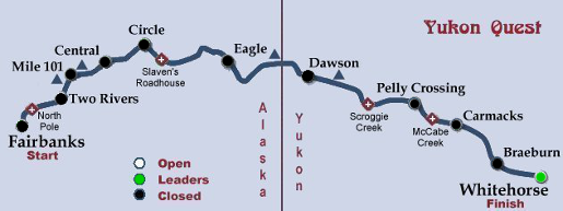
Note: This post will be updated during the day, and the map changed on all posts to reflect the current situation.
All posts on the Yukon Quest can be seen by clicking on the sled dog or selecting “Yukon Quest” from the Category box on the right sidebar.
February 6, 2016 Comments Off on Yukon Quest 2016 – Day 1
Yukon Quest Trail

Fairbanks 440 feet [134 meters] Start
Two Rivers 1550 feet [472 meters] 72 miles [116 km]
Rosebud Summit 3640 feet [1109 meters]
Mile 101 Steese Highway 2250 feet [686 meters] 42 miles [68 km]
Eagle Summit 3685 feet [1123 meters]
Central 435 feet [133 meters] 33 miles [53 km]
Circle City 597 feet [182 meters] 74 miles [119 km]
Eagle 880 feet [268 meters] 159 miles [256 km]
American Summit 3920 feet [1195 meters]
Dawson City 1050 feet [320 meters] 147 miles [237 km]
King Solomon’s Dome 4002 feet [1220 meters]
Pelly Crossing 1558 feet [475 meters] 202 miles [325 km]
Carmacks 1722 feet [525 meters] 73 miles [117 km]
Braeburn 2326 feet [709 meters] 77 miles [124 km]
Whitehorse 2089 feet [637 meters] 100 miles [161 km] Finish
The total distance is approximately 1000 miles [1600 kilometers]
[Two Rivers is also called Chena Hot Springs.]
February 6, 2016 Comments Off on Yukon Quest Trail


