
Iditarod 2016 Trail
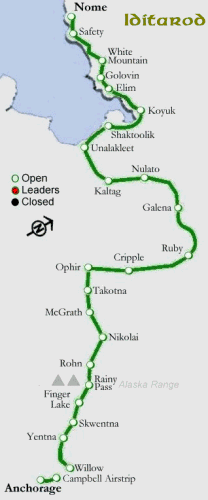 The trail and distances between checkpoints:
Willow – Start
Yentna Station – 52 miles [84 km]
Skwentna – 34 miles [55 km]
Finger Lake – 45 miles [72 km]
Rainy Pass – 30 miles [48 km]
Rohn – 48 miles [77 km]
Nikolai – 75 miles [121 km]
McGrath – 54 miles [87 km] [Spirit of Alaska]
Takotna – 18 miles [29 km]
Ophir – 25 miles [40 km]
Cripple – 59 miles [95 km] [Halfway]
Ruby – 112 miles [180 km] [First to the Yukon]
Galena – 52 miles [84 km]
Nulato – 52 miles [84 km]
Kaltag – 42 miles [68 km]
Unalakleet – 90 miles [145 km] [Gold Coast]
Shaktoolik – 42 miles [68 km]
Koyuk – 48 miles [77 km]
Elim – 48 miles [77 km]
Golovin – 28 miles [45 km]
White Mountain – 18 miles [29 km]
Safety – 55 miles [88 km]
Nome – 22 miles [35 km]
Note: The Saturday parade in Anchorage has been shortened to 3 miles from 11 so they wouldn’t have to import more snow from Fairbanks.
The items in italics after checkpoints are awards for being first to those points. The distance is from the previous checkpoint. Some teams in the early going will travel at 12 mph [20kph] or better with all 16 dogs eager to go. There are reasons not to do this.
March 3, 2016 Comments Off on Iditarod 2016 Trail


