
Bermuda Spiral?
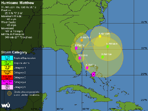
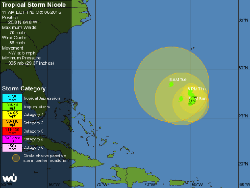
The 5-day forecast maps for Matthew and Nicole:
Either someone has been dancing too near the circles at ley line concentrations and opened an inter-dimensional rift … or climate change is doing very weird things.
October 6, 2016 6 Comments
Hurricane Matthew – Day 9
 Position: 27.1N 79.2W [10PM CDT 0300 UTC].
Movement: Northwest [325°] near 13 mph [20 kph].
Maximum sustained winds: 130 mph [210 kph].
Wind Gusts: 165 mph [265 kph].
Tropical Storm Wind Radius: 185 miles [295 km].
Hurricane Wind Radius: 60 miles [ 95 km].
Minimum central pressure: 939 mb ↑.
Currently about 50 miles [ 80 km] North-Northwest of Freeport, Grand Bahama Island – full effect hit at 4PM CDT.
Currently about 125 miles [ 200 km] Southeast of Cape Canaveral, Florida.
It is a minimum Category 4. The NHC web site went down right after I got the update for Nicole.
A Hurricane Warning is in effect for the Northwestern Bahamas, including the Abacos, Andros Island, Berry Islands, Bimini, Eleuthera, Grand Bahama Island, and New Providence, and Boca Raton, Florida to South Santee River, South Carolina including Lake Okeechobee.
A Tropical Storm Warning is in effect for Florida: Ocean Reef to south of Boca Raton, Anclote River to Suwannee River; and South Santee River, South Carolina to Surf City, North Carolina.
A Tropical Storm Watch is in effect for the Florida Gulf Coast North of Englewood to Anclote River.
Here’s the link for NOAA’s latest satellite images.
[For the latest information click on the storm symbol, or go to the CATEGORIES drop-down box below the CALENDAR and select “Hurricanes” for all of the posts related to storms on this site.]
October 6, 2016 2 Comments
Hurricane Nicole – Day 3
 Position: 27.4N 65.2W [10PM CDT 0300 UTC].
Movement: Stationary.
Maximum sustained winds: 105 mph [165 kph].
Wind Gusts: 125 mph [200 kph].
Tropical Storm Wind Radius: 90 miles [150 km].
Hurricane Wind Radius: 15 miles [ 30 km].
Minimum central pressure: 968 mb ↓.
Currently about 340 miles [ 545 km] South of Bermuda.
Here’s the link for NOAA’s latest satellite images.
[For the latest information click on the storm symbol, or go to the CATEGORIES drop-down box below the CALENDAR and select “Hurricanes” for all of the posts related to storms on this site.]
October 6, 2016 Comments Off on Hurricane Nicole – Day 3


