
Why I Stayed
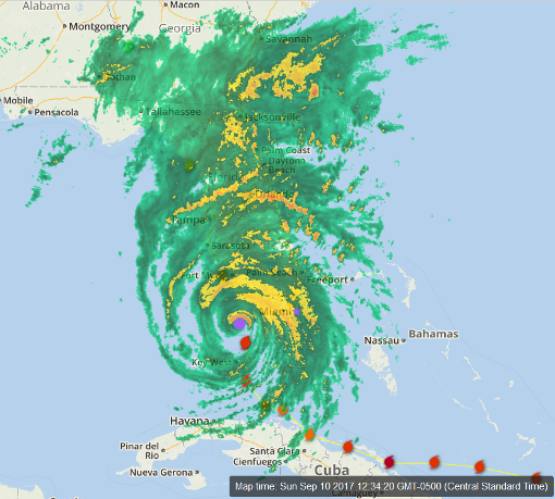
This is a screenshot of the Weather Underground’s WonderMap. I resized to fit in my blog window and added a purple dot to highlight the eye and a purple star to show Miami. I’m located about where the ‘s’ in Pensacola appears on the map. So far I’ve seen 25mph winds and cloudiness. They are forecasting rain tonight and/or tomorrow. Hurricanes aren’t circular, they are elliptical. The worst of the storm is in the Northeast quadrant. The winds move counterclockwise, they will be slowed by friction from the land before they get to me. If this had come into Mississippi or closer on the West side, I might not have hung around.
September 10, 2017 10 Comments
Hurricane Irma – Day 12
 Position: 27.5N 81.9W [10PM CDT 0300 UTC].
Movement: North [350°] near 14 mph [22 kph].
Maximum sustained winds: 100 mph [155 kph].
Wind Gusts: 130 mph [210 kph].
Tropical Storm Wind Radius: 415 miles [665 km].
Hurricane Wind Radius: 80 miles [130 km].
Minimum central pressure: 952 mb ↑.
Currently about 50 miles [ 80 km] Southeast of Tampa, Florida.
A Hurricane Warning is in effect for Fernandina North of Jupiter Inlet to Fernandina Beach; North of Bonita Beach to Indian Pass; Lake Okeechobee.
A Tropical Storm Warning is in effect for Jupiter Inlet southward around the Florida peninsula to Bonita Beach; Florida Keys; Florida Bay; West of Indian Pass to the Okaloosa/Walton County Line; North of Fernandina Beach to South Santee River.
A Storm Surge Warning is in effect for South Santee River southward to Jupiter Inlet; North Miami Beach southward around the Florida peninsula to the
Ochlockonee River; the Florida Keys; and Tampa Bay.
A Hurricane Watch is in effect for North of Fernandina Beach to Edisto Beach.
A Tropical Storm Watch is in effect for Bimini and Grand Bahama.
Here’s the link for NOAA’s latest satellite images.
[For the latest information click on the storm symbol, or go to the CATEGORIES drop-down box below the CALENDAR and select “Hurricanes” for all of the posts related to storms on this site.]
September 10, 2017 2 Comments
Hurricane Jose – Day 6
 Position: 23.7N 68.1W [10PM CDT 0300 UTC].
Movement: Northwest [325°] near 14 mph [22 kph].
Maximum sustained winds: 115 mph [185 kph].
Wind Gusts: 140 mph [225 kph].
Tropical Storm Wind Radius: 160 miles [260 km].
Hurricane Wind Radius: 35 miles [ 55 km].
Minimum central pressure: 962 mb ↑.
Currently about 245 miles [ 395 km] Northeast of Grand Turk Island.
Here’s the link for NOAA’s latest satellite images.
[For the latest information click on the storm symbol, or go to the CATEGORIES drop-down box below the CALENDAR and select “Hurricanes” for all of the posts related to storms on this site.]
September 10, 2017 Comments Off on Hurricane Jose – Day 6


