
Posts from — September 2022
Ian Wind Field 9/30
September 30, 2022 Comments Off on Ian Wind Field 9/30
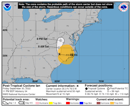
Post-Tropical Cyclone Ian – Day 8
 Position: 35.3N 79.5W [10:00PM CDT 0300UTC].
Movement: North [350°] near 15 mph [24 kph].
Maximum sustained winds: 50 mph [ 85 kph].
Wind Gusts: 60 mph [ 95 kph].
Tropical Storm Wind Radius: 195 miles [315 km].
Minimum central pressure: 994 mb ↑.
Currently about 60 miles [ 95 km] South-Southeast of Greensboro, North Carolina.
At 1PM CDT Ian is beginning its second landfall in the US.
Here’s the link for NOAA’s latest satellite images.
[For the latest information click on the storm symbol, or go to the CATEGORIES drop-down box below the CALENDAR and select “Hurricanes” for all of the posts related to storms on this site.]
September 30, 2022 Comments Off on Post-Tropical Cyclone Ian – Day 8
Remnant Eleven – Day 2
 Position: 19.1 37.4W [ 4:00PM CDT 2100UTC].
Movement: Northwest [320°] near 14 mph [22 kph].
Maximum sustained winds: 30 mph [ 45 kph].
Wind Gusts: 40 mph [ 65 kph].
Minimum central pressure: 1010 mb ↑.
Currently about 950 miles [1530 km] West-Northwest of the Cabo Verde Islands.
This is the final public advisory issued by the National Hurricane Center on this system.
Here’s the link for NOAA’s latest satellite images.
[For the latest information click on the storm symbol, or go to the CATEGORIES drop-down box below the CALENDAR and select “Hurricanes” for all of the posts related to storms on this site.]
September 29, 2022 Comments Off on Remnant Eleven – Day 2
Ian Wind Field 9/29
September 29, 2022 Comments Off on Ian Wind Field 9/29
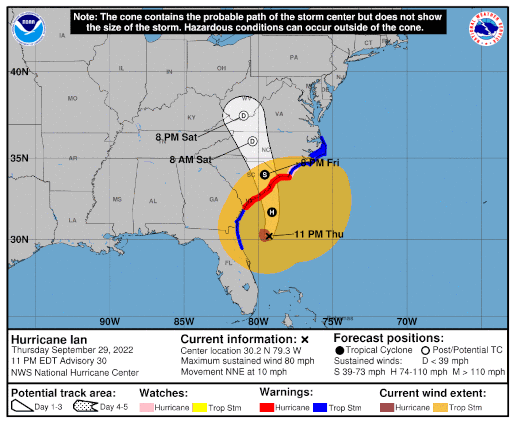
Hurricane Ian – Day 7
 Position: 30.2N 79.3W [10:00PM [CDT 0300UTC].
Movement: North-Northeast [030°] near 10 mph [17 kph].
Maximum sustained winds: 80 mph [130 kph].
Wind Gusts: 95 mph [155 kph].
Tropical Storm Wind Radius: 415 miles [665 km].
Hurricane Wind Radius: 45 miles [ 75 km].
Minimum central pressure: 986 mb.
Currently about 185 miles [ 295 km] South of Charleston, South Carolina.
Currently about 265 miles [ 430 km] South-Southwest of Cape Fear, North Carolina.
A Hurricane Warning is in effect for the Savannah River to Cape Fear.
A Tropical Storm Warning is in effect for the Flagler/Volusia County Line to Savannah River; Cape Fear to Duck, North Carolina; Pamlico Sound.
A Storm Surge Warning is in effect for the Flagler/Volusia Line to Cape Fear; St. Johns River; Neuse River.
A Hurricane Watch is in effect for East of Cape Fear to Surf City.
A Storm Surge Watch is in effect for North of Cape Fear to Duck, North Carolina; Pamlico River; Cape Fear River.
Here’s the link for NOAA’s latest satellite images.
[For the latest information click on the storm symbol, or go to the CATEGORIES drop-down box below the CALENDAR and select “Hurricanes” for all of the posts related to storms on this site.]
September 29, 2022 Comments Off on Hurricane Ian – Day 7
Tropical Depression Eleven
 Position: 17.2N 35.6W [10:00PM CDT 0300UTC].
Movement: North-Northwest [345°] near 10 mph [17 kph].
Maximum sustained winds: 35 mph [ 55 kph].
Wind Gusts: 45 mph [ 70 kph].
Minimum central pressure: 1008.
Currently about 770 miles [1240 km] West of the Cabo Verde Islands.
Here’s the link for NOAA’s latest satellite images.
[For the latest information click on the storm symbol, or go to the CATEGORIES drop-down box below the CALENDAR and select “Hurricanes” for all of the posts related to storms on this site.]
September 28, 2022 Comments Off on Tropical Depression Eleven
Ian Wind Field 9/28
September 28, 2022 Comments Off on Ian Wind Field 9/28
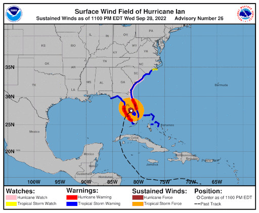
Hurricane Ian – Day 6
Position: 27.5N 81.4W [10:00PM [CDT 0300UTC].
Movement: North-Northeast [030°] near 8 mph [13 kph].
Maximum sustained winds: 90 mph [150 kph].
Wind Gusts: 105 mph [170 kph].
Tropical Storm Wind Radius: 175 miles [280 km].
Hurricane Wind Radius: 45 miles [ 75 km].
Minimum central pressure: 972 mb ↑.
Currently about 70 miles [ 150 km] South of Orlando, Florida.
Currently about 80 miles [ 110 km] Southwest of Cape Canaveral, Florida.
At 3:35PM CDT Ian made landfall between Fort Myers and Punta Gorda as a Category 4 storm with 145 mph sustained winds.
This is very bad for South Florida. A Category 4 landfall and the storm surge will be another Hurricane Andrew in effect.
A Hurricane Warning is in effect for Chokoloskee to the Anclote River, including Tampa Bay; Sebastian Inlet to Flagler/Volusia County Line.
A Tropical Storm Warning is in effect for Indian Pass to the Anclote River; Flamingo to Sebastian Inlet; Flamingo to Chokoloskee ;Flagler/Volusia County Line to Surf City; Lake Okeechobee; Bimini and Grand Bahama Islands.
A Storm Surge Warning is in effect for the Suwanee River southward to Flamingo; Tampa Bay; Flagler/Volusia Line to the mouth of the South Santee River; St. Johns River.
A Hurricane Watch is in effect for Flagler/Volusia County Line to the South Santee River.
A Tropical Storm Watch is in effect for North of Surf City to Cape Lookout.
A Storm Surge Watch is in effect for North of South Santee River to Little River Inlet.
Here’s the link for NOAA’s latest satellite images.
[For the latest information click on the storm symbol, or go to the CATEGORIES drop-down box below the CALENDAR and select “Hurricanes” for all of the posts related to storms on this site.]
September 28, 2022 Comments Off on Hurricane Ian – Day 6
Hurricane Ian – Day 5
 Position: 24.9N 82.9W [10:00PM [CDT 0300UTC].
Movement: North-Northeast [015°] near 10 mph [17 kph].
Maximum sustained winds: 120 mph [195 kph].
Wind Gusts: 140 mph [225 kph].
Tropical Storm Wind Radius: 140 miles [220 km].
Hurricane Wind Radius: 40 miles [ 65 km].
Minimum central pressure: 952 mb ↑.
Currently about 110 miles [ 175 km] Southwest of Naples, Florida.
A Hurricane Warning is in effect for Chokoloskee to the Anclote River, including Tampa Bay; Dry Tortugas.
A Tropical Storm Warning is in effect for the Cuban provinces of Isla de Juventud, Pinar del Rio, Artemisa, La Habana, Mayabeque, and Matanzas; Suwannee River to the Anclote River; Flamingo to South Santee River; Flamingo to Chokoloskee; All of the Florida Keys; Lake Okeechobee; Florida Bay; Bimini and Grand Bahama Islands.
A Storm Surge Warning is in effect for the Suwanee River southward to Flamingo; Tampa Bay; Dry Tortugas; Flagler/Volusia Line to the mouth of the St. Mary’s River; St. Johns River.
A Storm Surge Watch is in effect for the Florida Keys from the Card Sound Bridge westward to Key West; Florida Bay; Mouth of St. Mary’s River to South Santee River; South of Marineland to the Volusia/Flagler county line.
[For the latest information click on the storm symbol, or go to the CATEGORIES drop-down box below the CALENDAR and select “Hurricanes” for all of the posts related to storms on this site.]
September 27, 2022 Comments Off on Hurricane Ian – Day 5
Hurricane Ian – Day 4
 Position: 21.3N 83.4W [10:00PM [CDT 0300UTC].
Movement: North-Northwest [340°] near 13 mph [20 kph].
Maximum sustained winds: 105 mph [165 kph].
Wind Gusts: 120 mph [195 kph].
Tropical Storm Wind Radius: 115 miles [185 km].
Hurricane Wind Radius: 35 miles [ 55 km].
Minimum central pressure: 962 mb ↓.
Currently about 105 miles [ 170 km] East-Southeast of the western tip of Cuba.
A Hurricane Warning is in effect for the Cuban provinces of Isla de Juventud, Pinar del Rio, and Artemisa; Englewood to the Anclote River, including Tampa Bay; Dry Tortugas.
A Tropical Storm Warning is in effect for the Cuban provinces of La Habana, Mayabeque, and Matanzas; Lower Florida Keys from Seven Mile Bridge southward to Key West; Flamingo to Englewood.
A Storm Surge Warning is in effect for the Anclote River southward to Flamingo; Tampa Bay.
A Hurricane Watch is in effect for North of Anclote River to the Suwannee River; Bonita Beach to Englewood.
A Tropical Storm Watch is in effect for Florida Keys from Seven Mile Bridge to the Channel 5 Bridge; Lake Okeechobee;North of the Suwannee River to Indian Pass; Jupiter Inlet to Altamaha Sound.
A Storm Surge Watch is in effect for the Florida Keys from the Card Sound Bridge westward to Key West; Dry Tortugas; the West coast of Florida from Anclote River southward to the Card Sound Bridge; Florida Bay; Tampa Bay.
Here’s the link for NOAA’s latest satellite images.
[For the latest information click on the storm symbol, or go to the CATEGORIES drop-down box below the CALENDAR and select “Hurricanes” for all of the posts related to storms on this site.]
September 26, 2022 Comments Off on Hurricane Ian – Day 4
Tropical Storm Ian – Day 3
 Position: 17.3N 81.4W [10:00PM CDT 0300UTC].
Movement: Northwest [315°] near 13 mph [20 kph].
Maximum sustained winds: 65 mph [100 kph].
Wind Gusts: 80 mph [130 kph].
Tropical Storm Wind Radius: 70 miles [110 km].
Minimum central pressure: 989 mb ↓.
Currently about 140 miles [ 225 km] South of Grand Cayman.
A Hurricane Warning is in effect for Grand Cayman; the Cuban provinces of Isla de Juventud, Pinar del Rio, and Artemisa.
A Tropical Storm Warning is in effect for the Cuban provinces of La Habana, Mayabeque, and Matanzas; Seven Mile Bridge southward to Key West, including the Dry Tortugas.
A Tropical Storm Watch is in effect for Little Cayman and Cayman Brac; Englewood southward to Chokoloskee.
A Storm Surge Watch is in effect for the Florida Keys from the Card Sound Bridge westward to Key West; Dry Tortugas; the West coast of Florida from Englewood southward to the Card Sound Bridge; Florida Bay.
Here’s the link for NOAA’s latest satellite images.
[For the latest information click on the storm symbol, or go to the CATEGORIES drop-down box below the CALENDAR and select “Hurricanes” for all of the posts related to storms on this site.]
September 25, 2022 Comments Off on Tropical Storm Ian – Day 3
Post-Tropical Cyclone Gaston – Day 6
Position: 38.6N 38.2W [10:00PM CDT 0300UTC].
Movement: West-Southwest [245°] near 9 mph [15 kph].
Maximum sustained winds: 40 mph [ 65 kph].
Wind Gusts: 50 mph [ 80 kph].
Tropical Storm Wind Radius: 70 miles (110 km].
Minimum central pressure: 1005 mb ↑.
Currently about 510 miles [ 825 km] West of Faial Island in the central Azores.
This is the last public advisory issued by the National Hurricane Center on this system.
Here’s the link for NOAA’s latest satellite images.
[For the latest information click on the storm symbol, or go to the CATEGORIES drop-down box below the CALENDAR and select “Hurricanes” for all of the posts related to storms on this site.]
September 25, 2022 Comments Off on Post-Tropical Cyclone Gaston – Day 6
Post-Tropical Cyclone Hermine – Day 3
Position: 23.6N 20.2W [ 4:00AM CDT 0900 UTC].
Movement: North [010°] near 7 mph [11 kph].
Maximum sustained winds: 30 mph [ 45 kph].
Wind Gusts: 40 mph [ 65 kph].
Minimum central pressure: 1008 mb ↑.
Currently about 580 miles [ 935 km] North-Northeast of the Cabo Verde Islands.
This is the last public advisory issued by the National Hurricane Center on Hermine.
Here’s the link for NOAA’s latest satellite images.
[For the latest information click on the storm symbol, or go to the CATEGORIES drop-down box below the CALENDAR and select “Hurricanes” for all of the posts related to storms on this site.]
September 25, 2022 Comments Off on Post-Tropical Cyclone Hermine – Day 3
L’shanah Tovah

Happy 5783!
At sunset Rosh Hashanah [רֹאשׁ הַשָּׁנָה] begins, so get your honey, challah, and apples ready.
September 25, 2022 Comments Off on L’shanah Tovah


