
Posts from — November 2022
Nicole Wind Field 11/8
At Noon CST Nicole is beginning to spin up. The barometric pressure is already low enough for a hurricane. (The times on the graphic are Eastern Standard Time)
Get out and vote, you have time.
November 8, 2022 2 Comments
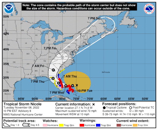
Tropical Storm Nicole – Day 2
 Position: 27.1N 74.8W [ 9:00PM CST 0300UTC].
Movement: West-Southwest [250°] near 10 mph [17 kph].
Maximum sustained winds: 70 mph [110 kph].
Wind Gusts: 80 mph [130 kph].
Tropical Storm Wind Radius: 380 mph [610 kph].
Minimum central pressure: 984 mb.
Currently about 325 miles [ 525 km] East of West Palm Beach, Florida.
A Hurricane Warning is in effect for the Northwest Bahamas, including the Abacos, Berry Islands,Bimini, & Grand Bahama Island; Boca Raton to Flagler/Volusia County Line, Florida.
A Tropical Storm Warning is in effect for Andros Island, New Providence, & Eleuthera; Hallandale Beach, Florida to Boca Raton, Florida; Flagler/Volusia County Line, Florida to Altamaha Sound, Georgia; Lake Okeechobee.
A Storm Surge Warning is in effect for North Palm Beach, Florida to Altamaha Sound; Mouth of the St. Johns River to Georgetown, Florida.
A Hurricane Watch is in effect for the Coast of Florida from Hallandale Beach to Boca Raton, Florida; Flagler/Volusia County Line to Ponte Vedra Beach; Lake Okeechobee.
A Tropical Storm Watch is in effect for Hallandale Beach to north of Ocean Reef, Florida; North of Bonita Beach to the Ochlockonee River, Florida; north of Altamaha Sound, Georgia to South Santee River, South Carolina.
A Storm Surge Watch is in effect for North Palm Beach to Hallandale Beach, Florida; Altamaha Sound, Georgia to South Santee River, South Carolina; Anclote River, Florida to Indian Pass, Florida.
Here’s the link for NOAA’s latest satellite images.
[For the latest information click on the storm symbol, or go to the CATEGORIES drop-down box below the CALENDAR and select “Hurricanes” for all of the posts related to storms on this site.]
November 8, 2022 Comments Off on Tropical Storm Nicole – Day 2
Nicole Wind Field 11/7
Ian attacked the Gulf side of the Peninsula, now Nicole is going for the Atlantic Coast. This is why you should vote early in Florida. For someone who claims to be anointed by G-d, DeMentis doesn’t seem to have too much pull concerning the weather.
November 7, 2022 Comments Off on Nicole Wind Field 11/7
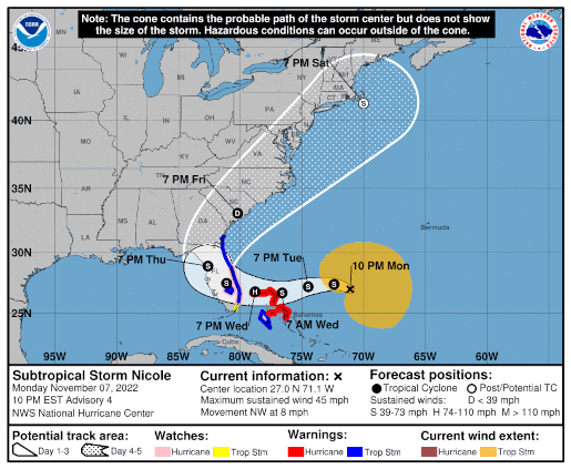
Subtropical Storm Nicole
Position: 27.0N 71.1W [ 9:00PM CST 0300UTC].
Movement: Northwest [310°] near 8 mph [13 kph].
Maximum sustained winds: 45 mph [ 75 kph].
Wind Gusts: 55 mph [ 90 kph].
Tropical Storm Wind Radius: 310 mph [500 kph].
Minimum central pressure: 998 mb.
Currently about 415 miles [ 665 km] East-Northeast of the northwestern Bahamas.
A Hurricane Warning is in effect for the Northwest Bahamas, including the Abacos, Berry Islands,Bimini, & Grand Bahama Island.
A Tropical Storm Warning is in effect for Andros Island, New Providence, & Eleuthera; Hallandale Beach to Altamaha Sound; Lake Okeechobee.
A Storm Surge Warning is in effect for North Palm Beach to Altamaha Sound; Mouth of the St. Johns River to Georgetown.
A Hurricane Watch is in effect for the East Coast of Florida from the Volusia/Brevard County Line to Hallandale Beach; Lake Okeechobee.
A Tropical Storm Watch is in effect for Hallandale Beach to north of Ocean Reef.
A Storm Surge Watch is in effect for North Palm Beach to Hallandale Beach.
Here’s the link for NOAA’s latest satellite images.
[For the latest information click on the storm symbol, or go to the CATEGORIES drop-down box below the CALENDAR and select “Hurricanes” for all of the posts related to storms on this site.]
November 7, 2022 Comments Off on Subtropical Storm Nicole
Remnants Lisa – Day 7
 Position: 21.2N 95.2W [10:00AM CDT 1500UTC].
Movement: North [005°] near 5 mph [ 7 kph].
Maximum sustained winds: 25 mph [ 35 kph].
Wind Gusts: 35 mph [ 50 kph].
Minimum central pressure: 1008 mb.
Currently about 150 miles [ 245 km] North-Northeast of Veracruz, Mexico.
This is the last public advisory issued by the National Hurricane Center on this system.
Here’s the link for NOAA’s latest satellite images.
[For the latest information click on the storm symbol, or go to the CATEGORIES drop-down box below the CALENDAR and select “Hurricanes” for all of the posts related to storms on this site.]
November 5, 2022 Comments Off on Remnants Lisa – Day 7
US Clock Change This Weekend

Daylight Savings Time will end in the US Sunday morning, November 6th at 2AM. It will become 1AM and you get an extra hour of sleep, unless you work the “graveyard shift” or forget.
“Fall back – Spring ahead”
November 5, 2022 Comments Off on US Clock Change This Weekend
Happy Bonfire Night
 Remember, remember the fifth of November
Gunpowder, treason and plot.
I see no reason why gunpowder, treason
Should ever be forgot.
The British are celebrating the anniversary of the thwarting of the Gunpowder Plot.
A group of English Catholic conspirators including an explosives expert, Guy Fawkes, stashed 36 barrels of gunpowder in the basement of the Parliament building with the intent of blowing up the members of Parliament and King James I during the official opening of Parliament on November 5th, 1605.
Bonfire Night is celebrated with bonfires and fireworks. Effigies of Guy Fawkes, and occasionally the Pope, are traditionally thrown on the fires. Effigies of modern politicians have made their appearances at the celebration.
As Robert Cecil was involved, I doubt anyone will ever know the truth about the plot.
November 5, 2022 Comments Off on Happy Bonfire Night
Tropical Depression Lisa – Day 6
 Position: 19.5N 95.5W [10:00PM CDT 0300UTC].
Movement: North [350°] near 3 mph [ 6 kph].
Maximum sustained winds: 30 mph [ 45 kph].
Wind Gusts: 40 mph [ 65 kph].
Minimum central pressure: 1008 mb.
Currently about 250 miles [ 400 km] West-Northwest of Ciudad del Carmen, Mexico.
Here’s the link for NOAA’s latest satellite images.
[For the latest information click on the storm symbol, or go to the CATEGORIES drop-down box below the CALENDAR and select “Hurricanes” for all of the posts related to storms on this site.]
November 4, 2022 Comments Off on Tropical Depression Lisa – Day 6
Post-Tropical Cyclone Martin – Day 3
 Position: 50.5N 34.5W [ 4:00PM CDT 2100UTC].
Movement: East-Northeast [020°] near 58 mph [93 kph].
Maximum sustained winds: 80 mph [130 kph].
Wind Gusts: 95 mph [155 kph].
Tropical Storm Wind Radius: 520 miles (835 km].
Hurricane Wind Radius: 70 miles [110 km].
Minimum central pressure: 950 mb ↓.
Currently about 885 miles [1425 km] East-Northeast of Cape Race, Newfoundland.
This is the last public advisory issued by the National Hurricane Center on this system.
Here’s the link for NOAA’s latest satellite images.
[For the latest information click on the storm symbol, or go to the CATEGORIES drop-down box below the CALENDAR and select “Hurricanes” for all of the posts related to storms on this site.]
November 3, 2022 9 Comments
Tropical Depression Lisa – Day 5
Position: 18.1N 93.1W [10:00PM CDT 0300UTC].
Movement: West [275°] near 12 mph [19 kph].
Maximum sustained winds: 30 mph [ 45 kph].
Wind Gusts: 40 mph [ 65 kph].
Minimum central pressure: 1009 mb ↑.
Currently about 95 miles [ 150 km] West-Southwest of Ciudad del Carmen, Mexico.
Here’s the link for NOAA’s latest satellite images.
[For the latest information click on the storm symbol, or go to the CATEGORIES drop-down box below the CALENDAR and select “Hurricanes” for all of the posts related to storms on this site.]
November 3, 2022 Comments Off on Tropical Depression Lisa – Day 5
Hurricane Martin – Day 2
 Position: 39.4N 44.9W [10:00PM CDT 0300UTC].
Movement: Northeast [040°] near 39 mph [63 kph].
Maximum sustained winds: 85 mph [140 kph].
Wind Gusts: 95 mph [155 kph].
Tropical Storm Wind Radius: 175 miles (280 km].
Hurricane Wind Radius: 45 miles [ 75 km].
Minimum central pressure: 973 mb ↓.
Currently about 650 miles [1050 km] Southeast of Cape Race, Newfoundland.
Here’s the link for NOAA’s latest satellite images.
[For the latest information click on the storm symbol, or go to the CATEGORIES drop-down box below the CALENDAR and select “Hurricanes” for all of the posts related to storms on this site.]
November 2, 2022 Comments Off on Hurricane Martin – Day 2
Tropical Storm Lisa – Day 4
Position: 17.6N 89.1W [10:00PM CDT 0300UTC].
Movement: West [280°] near 12 mph [19 kph].
Maximum sustained winds: 60 mph [ 95 kph].
Wind Gusts: 75 mph [120 kph].
Tropical Storm Wind Radius: 70 mph [110 kph].
Minimum central pressure: 995 mb ↑.
Currently about 60 miles [ 95 km] West of Belize City.
The storm is inland in Belize at 7PM CDT.
A Tropical Storm Warning is in effect for the coast of Belize; Chetumal to Puerto Costa Maya, Mexico.
Here’s the link for NOAA’s latest satellite images.
[For the latest information click on the storm symbol, or go to the CATEGORIES drop-down box below the CALENDAR and select “Hurricanes” for all of the posts related to storms on this site.]
November 2, 2022 Comments Off on Tropical Storm Lisa – Day 4
Tropical Storm Martin
Position: 35.1N 53.4W [10:00PM CDT 0300UTC].
Movement: East [100°] near 10 mph [17 kph].
Maximum sustained winds: 60 mph [ 95 kph].
Wind Gusts: 75 mph [120 kph].
Tropical Storm Wind Radius: 105 miles (165 km].
Minimum central pressure: 991 mb.
Currently about 680 miles [1100 km] East-Northeast of Bermuda.
Here’s the link for NOAA’s latest satellite images.
[For the latest information click on the storm symbol, or go to the CATEGORIES drop-down box below the CALENDAR and select “Hurricanes” for all of the posts related to storms on this site.]
November 1, 2022 Comments Off on Tropical Storm Martin
Tropical Storm Lisa – Day 3
Position: 16.8N 84.7W [10:00PM CDT 0300UTC].
Movement: West [280°] near 15 mph [24 kph].
Maximum sustained winds: 70 mph [110 kph].
Wind Gusts: 80 mph [130 kph].
Tropical Storm Wind Radius: 70 mph [110 kph].
Minimum central pressure: 993 mb ↓.
Currently about 235 miles [ 380 km] East of Belize City.
A Hurricane Warning is in effect for the Bay Islands; the entire coast of Belize; Chetumal to Puerto Costa Maya, Mexico.
A Tropical Storm Warning is in effect for the entire north coast of Honduras; north coast of Guatemala; Puerto Costa Maya to Punta Allen, Mexico.
Here’s the link for NOAA’s latest satellite images.
[For the latest information click on the storm symbol, or go to the CATEGORIES drop-down box below the CALENDAR and select “Hurricanes” for all of the posts related to storms on this site.]
November 1, 2022 Comments Off on Tropical Storm Lisa – Day 3


