
Posts from — August 2017
Karma
Trump pardons Arpaio sending a signal to people in the Mueller investigation that he can pardon them and Politico reports that Mueller has teamed up with New York attorney general in Manafort probe.
New York State Attorney General Eric Schneiderman dinged Trump for $25 million over the Trump University case and will certainly enjoy having another go. He will now have access to fruits of the Federal investigation, as well as giving the Feds what he has been hoarding about Trump. The Presidential pardon doesn’t apply to state charges, i.e. the President can pardon treason, but he can’t fix a speeding ticket.
The CBC notes that Trump cancelled a program that would have helped disaster recovery:
Two weeks before Harvey’s flood waters engulfed much of Houston, U.S. President Donald Trump quietly rolled back an order by his predecessor that would have made it easier for storm-ravaged communities to use federal emergency aid to rebuild bridges, roads and other structures so they can better withstand future disasters.
Now, with much of the nation’s fourth-largest city underwater, Trump’s move has new resonance. Critics note the president’s order could force Houston and other cities to rebuild hospitals and highways in the same way and in the same flood-prone areas.
Back in 1995 during the recovery from Hurricane Opal we got new traffic lights that were designed to withstand 200 mph winds. Almost every light in the south county had been blown down, not for the first time, and FEMA under Clinton paid to upgrade them, so they wouldn’t have to keep replacing them. The lights are still standing after Ivan and Dennis, so it was a good investment.
Take a break for something that could have been written by Groucho Marx.
August 31, 2017 2 Comments
Hurricane Irma – Day 2
 Position: 17.8N 35.6W [10PM CDT 0300 UTC].
Movement: West-Northwest [295°] near 12 mph [19 kph].
Maximum sustained winds: 115 mph [185 kph].
Wind Gusts: 135 mph [215 kph].
Tropical Storm Wind Radius: 90 miles [150 km].
Hurricane Wind Radius: 15 miles [ 30 km].
Minimum central pressure: 967 mb.
Currently about 1725 miles [2775 km] East of the Leeward Islands.
The pressure is dropping like a rock, and Irma is a Category 3 major hurricane at 4PM CDT.
Here’s the link for NOAA’s latest satellite images.
[For the latest information click on the storm symbol, or go to the CATEGORIES drop-down box below the CALENDAR and select “Hurricanes” for all of the posts related to storms on this site.]
August 31, 2017 Comments Off on Hurricane Irma – Day 2
Minutiae?
For all of the people who don’t remember what happened when Hurricane Rita threatened Houston in 2005 you can read the NPR story or that of Adrastos at First Draft who was still cleaning up from Katrina when it hit. The short version is that more than ten times as many people died trying to evacuate, than those who didn’t. Texas has not corrected any of the major deficiencies that created the disaster in 2005, so it was probable that with an increased population the death toll would be even higher than over a 100 dead.
Meanwhile Susie Madrak has discovered the real reason for Trump going to Texas: selling hats. Curse his heart for the shriveled prune that it is, there is not a hint of empathy or compassion in that man’s soul. The fourth largest city in the US is under water, tens of thousands of people are homeless, an unknown number are dead, and the so-called President of the United States is hawking tchotchkes on the public’s dime.
August 30, 2017 19 Comments
Tropical Storm Irma
 Position: 16.4N 32.2W [10PM CDT 0300 UTC].
Movement: West [275°] near 15 mph [24 kph].
Maximum sustained winds: 65 mph [100 kph].
Wind Gusts: 80 mph [130 kph].
Tropical Storm Wind Radius: 60 miles [ 95 km].
Minimum central pressure: 999 mb ↓.
Currently about 545 miles [ 875 km] West of the Cabo Verde Islands.
Here’s the link for NOAA’s latest satellite images.
[For the latest information click on the storm symbol, or go to the CATEGORIES drop-down box below the CALENDAR and select “Hurricanes” for all of the posts related to storms on this site.]
August 30, 2017 Comments Off on Tropical Storm Irma
Tropical Depression Harvey – Part II Day 8
 Position: 31.7N 92.3W [10PM CDT 0300 UTC].
Movement: North-Northeast [030°] near 9 mph [15 kph].
Maximum sustained winds: 35 mph [ 55 kph].
Wind Gusts: 50 mph [ 80 kph].
Minimum central pressure: 998 mb.
Currently about 30 miles [ 50 km] North-Northeast of Alexandria, Louisiana.
At 4AM CDT the storm made landfall just west of Cameron, Louisiana.
At 10PM CDT the NHC issued its last public advisory on Part II of Harvey.
Here’s the link for NOAA’s latest satellite images.
[For the latest information click on the storm symbol, or go to the CATEGORIES drop-down box below the CALENDAR and select “Hurricanes” for all of the posts related to storms on this site.]
August 30, 2017 Comments Off on Tropical Depression Harvey – Part II Day 8
Katrina

It wasn’t the storm, it was the levees.
It wasn’t Nature, it was man.
August 29, 2017 Comments Off on Katrina
Potential Tropical Cyclone Ten – Day 3
 Position: 36.0N 74.3W [ 4PM CDT 2100 UTC].
Movement: Northeast [050°] near 24 mph [39 kph].
Maximum sustained winds: 45 mph [ 75 kph].
Wind Gusts: 55 mph [ 90 kph].
Tropical Storm Wind Radius: 105 miles [165 km].
Minimum central pressure: 1003 mb ↓.
Currently about 85 miles [ 140 km] Northeast of Cape Hatteras, North Carolina.
All watches and warnings have been cancelled. This is the final NHC advisory.
Here’s the link for NOAA’s latest satellite images.
[For the latest information click on the storm symbol, or go to the CATEGORIES drop-down box below the CALENDAR and select “Hurricanes” for all of the posts related to storms on this site.]
August 29, 2017 Comments Off on Potential Tropical Cyclone Ten – Day 3
Tropical Storm Harvey – Part II Day 7
 Position: 29.0N 93.6W [10PM CDT 0300 UTC].
Movement: Northeast [035°] near 6 mph [ 9 kph].
Maximum sustained winds: 50 mph [ 85 kph].
Wind Gusts: 65 mph [100 kph].
Tropical Storm Wind Radius: 160 miles [260 km].
Minimum central pressure: 994 mb.
Currently about 65 miles [ 105 km] South-Southeast of Port Arthur, Texas.
A Tropical Storm Warning is in effect for North of Freeport, Texas to Grand Isle, Louisiana.
A Storm Surge Warning is in effect for Holly Beach to Morgan City, Louisiana.
A Storm Surge Watch is in effect for Port Bolivar, Texas, to Holly Beach, Louisiana.
Here’s the link for NOAA’s latest satellite images.
[For the latest information click on the storm symbol, or go to the CATEGORIES drop-down box below the CALENDAR and select “Hurricanes” for all of the posts related to storms on this site.]
August 29, 2017 8 Comments
Potential Tropical Cyclone Ten – Day 2
Position: 32.5N 80.0W [10PM CDT 0300 UTC].
Movement: North-Northeast [020°] near 7 mph [11 kph].
Maximum sustained winds: 40 mph [ 65 kph].
Wind Gusts: 55 mph [ 90 kph].
Minimum central pressure: 1005 mb ↓.
Currently about 20 miles [ 35 km] South-Southwest of Charleston, South Carolina.
A Tropical Storm Warning is in effect for Surf City to Duck, North Carolina, including Albemarle and Pamlico Sound.
A Tropical Storm Watch is in effect for South Santee River, South Carolina, to Surf City, North Carolina.
Here’s the link for NOAA’s latest satellite images.
[For the latest information click on the storm symbol, or go to the CATEGORIES drop-down box below the CALENDAR and select “Hurricanes” for all of the posts related to storms on this site.]
August 28, 2017 Comments Off on Potential Tropical Cyclone Ten – Day 2
Tropical Storm Harvey – Part II Day 6
Position: 28.2N 95.3W [10PM CDT 0300 UTC].
Movement: East-Southeast [120°] near 3 mph [ 5 kph].
Maximum sustained winds: 45 mph [ 75 kph].
Wind Gusts: 60 mph [ 95 kph].
Tropical Storm Wind Radius: 175 miles [280 km].
Minimum central pressure: 997 mb.
Currently about 70 miles [ 110 km] East of Port O’Connor, Texas.
Harvey has made it back to the Gulf at 7AM and is beginning to strengthen.
A Tropical Storm Warning is in effect for Mesquite Bay, Texas to Intracoastal City, Louisiana.
A Storm Surge Watch is in effect for Port Bolivar, Texas, to Morgan City, Louisiana.
Here’s the link for NOAA’s latest satellite images.
[For the latest information click on the storm symbol, or go to the CATEGORIES drop-down box below the CALENDAR and select “Hurricanes” for all of the posts related to storms on this site.]
August 28, 2017 Comments Off on Tropical Storm Harvey – Part II Day 6
Potential Tropical Cyclone Ten
Position: 30.5N 80.8W [10PM CDT 0300 UTC].
Movement: Stationary.
Maximum sustained winds: 35 mph [ 55 kph].
Wind Gusts: 50 mph [ 80 kph].
Minimum central pressure: 1007 mb.
Currently about 165 miles [ 270 km] South-Southwest of Charleston, South Carolina.
A Tropical Storm Watch is in effect for South Santee River, South Carolina, to Duck, North Carolina, including Albemarle and Pamlico Sounds.
Here’s the link for NOAA’s latest satellite images.
[For the latest information click on the storm symbol, or go to the CATEGORIES drop-down box below the CALENDAR and select “Hurricanes” for all of the posts related to storms on this site.]
August 27, 2017 Comments Off on Potential Tropical Cyclone Ten
Not Good
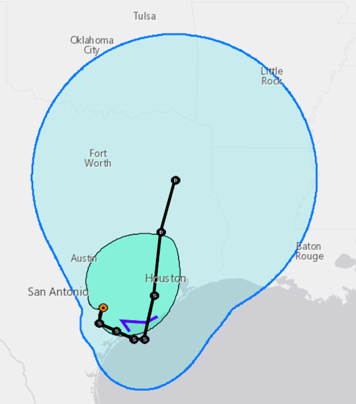
What the National Hurricane Center is predicting will be the track for Harvey’s next five days – back to the Gulf and then North by Houston as a tropical storm.
August 27, 2017 Comments Off on Not Good
Tropical Storm Harvey – Part II Day 5
Position: 28.8N 96.6W [10PM CDT 0300 UTC].
Movement: East-Southeast [120°] near 3 mph [ 6 kph].
Maximum sustained winds: 40 mph [ 65 kph].
Wind Gusts: 50 mph [ 80 kph].
Tropical Storm Wind Radius: 140 miles [220 km].
Minimum central pressure: 1000 mb.
Currently about 10 miles [ 15 km] East of Victoria, Texas.
Houston is already experiencing massive flooding, and the flooding will continue.
A Tropical Storm Warning is in effect for Mesquite Bay to High Island, Texas.
A Tropical Storm Watch is in effect for North of Sargent to San Luis Pass, Texas.
Here’s the link for NOAA’s latest satellite images.
[For the latest information click on the storm symbol, or go to the CATEGORIES drop-down box below the CALENDAR and select “Hurricanes” for all of the posts related to storms on this site.]
August 27, 2017 8 Comments
Tropical Storm Harvey – Part II Day 4
Position: 29.3N 97.3W [10PM CDT 0300 UTC].
Movement: East-Northeast [060°] near 1 mph [ 2 kph].
Maximum sustained winds: 50 mph [ 85 kph].
Wind Gusts: 65 mph [100 kph].
Tropical Storm Wind Radius: 115 miles [185 km].
Minimum central pressure: 994 mb ↑.
Currently about 40 miles [ 65 km] Northwest of Victoria, Texas.
At 1PM CDT Harvey was downgraded to a tropical storm. Because it is moving so slowly, there is a major threat of catastrophic flooding.
A Tropical Storm Warning is in effect for Baffin Bay to Sargent, Texas.
A Storm Surge Warning is in effect for Port Aransas to Sargent, Texas.
Here’s the link for NOAA’s latest satellite images.
[For the latest information click on the storm symbol, or go to the CATEGORIES drop-down box below the CALENDAR and select “Hurricanes” for all of the posts related to storms on this site.]
August 26, 2017 Comments Off on Tropical Storm Harvey – Part II Day 4


