
I Ain’t Dead
Lots of hospital time but I’m still around mostly on Apple stuff.
My life is in turmoil at the moment, but I suspect I’ll be back by Xmas.
October 11, 2024 4 Comments
Hurricane Ernesto – Day 8
 Position: 37.1N 62.3W [ 4:00PM CDT 2100 UTC].
Movement: North-Northeast [025] near 17 mph [28 kph].
Maximum sustained winds: 75 mph [120 kph].
Wind Gusts: 90 mph [145 kph].
Tropical Storm Wind Radius: 220 miles (350 km).
Hurricane Wind Radius: 35 miles [ 55 km].
Minimum central pressure: 977 mb ↓.
Currently about 520 miles [ 844 km] South of Halifax, Nova Scotia.
Here’s the link for NOAA’s latest satellite images.
[For the latest information click on the storm symbol, or go to the CATEGORIES drop-down box below the CALENDAR and select “Hurricanes” for all of the posts related to storms on this site.]
August 17, 2024 Comments Off on Hurricane Ernesto – Day 8
Hurricane Ernesto – Day 6
Position: 31.4N 65.2W [10:00PM CDT 0300 UTC].
Movement: North-Northeast [030°] near 13 mph [20 kph].
Maximum sustained winds: 90 mph [150 kph].
Wind Gusts: 105 mph [170 kph].
Tropical Storm Wind Radius: 275 miles (445 km).
Hurricane Wind Radius: 70 miles [110 km].
Minimum central pressure: 969 mb.
Currently about 65 miles [ 105 km] South-Southwest of Bermuda.
A Hurricane Warning is in effect for Bermuda.
Here’s the link for NOAA’s latest satellite images.
[For the latest information click on the storm symbol, or go to the CATEGORIES drop-down box below the CALENDAR and select “Hurricanes” for all of the posts related to storms on this site.]
August 16, 2024 Comments Off on Hurricane Ernesto – Day 6
Hurricane Ernesto – Day 5
 Position: 27.1N 68.1W [10:00PM CDT 0300 UTC].
Movement: North-Northeast [025°] near 14 mph [22 kph].
Maximum sustained winds: 100 mph [155 kph].
Wind Gusts: 115 mph [185 kph].
Tropical Storm Wind Radius: 265 miles (425 km).
Hurricane Wind Radius: 60 miles [ 95 km].
Minimum central pressure: 968 mb ↓.
Currently about 410 miles [ 660 km] South-Southwest of Bermuda.
A Hurricane Warning is in effect for Bermuda.
Here’s the link for NOAA’s latest satellite images.
[For the latest information click on the storm symbol, or go to the CATEGORIES drop-down box below the CALENDAR and select “Hurricanes” for all of the posts related to storms on this site.]
August 15, 2024 Comments Off on Hurricane Ernesto – Day 5
Hurricane Ernesto – Day 4
Position: 23.0N 68.9W [10:00PM CDT 0300 UTC].
Movement: North-Northwest [330°] near 16 mph [26 kph].
Maximum sustained winds: 80 mph [130 kph].
Wind Gusts: 95omph [155 kph].
Tropical Storm Wind Radius: 175 miles (280 km).
Hurricane Wind Radius: 45 miles [ 75 km].
Minimum central pressure: 982 mb ↓.
Currently about 690 miles [1110 km] South-Southwest of Bermuda.
A Hurricane Watch is in effect for Bermuda.
Here’s the link for NOAA’s latest satellite images.
[For the latest information click on the storm symbol, or go to the CATEGORIES drop-down box below the CALENDAR and select “Hurricanes” for all of the posts related to storms on this site.]
August 14, 2024 Comments Off on Hurricane Ernesto – Day 4
Tropical Storm Ernesto – Day 3
 Position: 18.8N 65.3W [10:00PM CDT 0300 UTC].
Movement: Northwest [305°] near 17 mph [28 kph].
Maximum sustained winds: 65 mph [100 kph].
Wind Gusts: 75 mph [120 kph].
Tropical Storm Wind Radius: 125 miles (205 km).
Minimum central pressure: 998 mb ↓.
Currently about 60 miles [ 95 km] East-Northeast of San Juan, Puerto Rico.
A Tropical Storm Warning is in effect for British Virgin Islands; U.S. Virgin Islands; Puerto Rico; Vieques; Culebra.
A Hurricane Watch is in effect for British Virgin Islands; U.S. Virgin Islands; Vieques; Culebra.
Here’s the link for NOAA’s latest satellite images.
[For the latest information click on the storm symbol, or go to the CATEGORIES drop-down box below the CALENDAR and select “Hurricanes” for all of the posts related to storms on this site.]
August 13, 2024 Comments Off on Tropical Storm Ernesto – Day 3
Tropical Storm Ernesto – Day 2
Position: 16.0N 59.6W [10:00PM CDT 0300 UTC].
Movement: West [275°] near 25 mph [41 kph].
Maximum sustained winds: 40 mph [ 65 kph].
Wind Gusts: 50 mph [ 80 kph].
Tropical Storm Wind Radius: 80 miles (130 km).
Minimum central pressure: 1009 mb.
Currently about 165 miles [ 265 km] East-Southeast of Antigua.
A Tropical Storm Warning is in effect for St. Kitts, Nevis, Montserrat, Antigua, Barbuda, and Anguilla; Guadeloupe; St. Martin and St. Barthelemy; Sint Maarten; British Virgin Islands; U.S. Virgin Islands; Puerto Rico; Vieques; Culebra.
Here’s the link for NOAA’s latest satellite images.
[For the latest information click on the storm symbol, or go to the CATEGORIES drop-down box below the CALENDAR and select “Hurricanes” for all of the posts related to storms on this site.]
August 12, 2024 Comments Off on Tropical Storm Ernesto – Day 2
Potential Tropical Cyclone Five
 Position: 14.1N 50.1W [10:00PM CDT 0300 UTC].
Movement: West-Northwest [285°] near 23 mph [37 kph].
Maximum sustained winds: 30 mph [ 45 kph].
Wind Gusts: 40 mph [ 65 kph].
Minimum central pressure: 1009 mb ↓.
Currently about 805 miles [1295 km] East-Southeast of Antigua.
A Tropical Storm Watch is in effect for Guadeloupe; St. Kitts, Nevis, Montserrat, Antigua, Barbuda, and Anguilla; Saba and St. Eustatius; St. Martin and St. Barthelemy; Sint Maarten; British Virgin Islands; U.S. Virgin Islands.
Here’s the link for NOAA’s latest satellite images.
[For the latest information click on the storm symbol, or go to the CATEGORIES drop-down box below the CALENDAR and select “Hurricanes” for all of the posts related to storms on this site.]
August 11, 2024 Comments Off on Potential Tropical Cyclone Five
Tropical Depression Debby – Day 7
 Position: 35.1N 80.2W [ 4:00PM CDT 2100 UTC].
Movement: North-Northwest [345°] near 10 mph [17 kph].
Maximum sustained winds: 35 mph [ 55 kph].
Wind Gusts: 50 mph [ 80 kph].
Minimum central pressure: 998 mb ↑.
Currently about 45 miles [ 45 km] East of Charlotte, North Carolina.
All Watches and Warnings have been cancelled. This is the last public advisory issued by the National Hurricane Center on Debby.
Here’s the link for NOAA’s latest satellite images.
[For the latest information click on the storm symbol, or go to the CATEGORIES drop-down box below the CALENDAR and select “Hurricanes” for all of the posts related to storms on this site.]
August 8, 2024 Comments Off on Tropical Depression Debby – Day 7
Tropical Storm Debby – Day 6
Position: 32.9N 79.5W [10:00PM CDT 0300 UTC].
Movement: North-Northwest [345°] near 3 mph [ 6 kph].
Maximum sustained winds: 60 mph [ 95 kph].
Wind Gusts: 70 mph [115 kph].
Tropical Storm Wind Radius: 185 miles (295 km).
Minimum central pressure: 994 mb ↓.
Currently about 65 miles [ 105 km] South-Southwest of Myrtle Beach, South Carolina.
A Tropical Storm Warning is in effect for Edisto Beach, South Carolina to Surf City, North Carolina.
A Tropical Storm Watch is in effect for North of Surf City, North Carolina to Beaufort Inlet, North Carolina.
Here’s the link for NOAA’s latest satellite images.
[For the latest information click on the storm symbol, or go to the CATEGORIES drop-down box below the CALENDAR and select “Hurricanes” for all of the posts related to storms on this site.]
August 7, 2024 Comments Off on Tropical Storm Debby – Day 6
Tropical Storm Debby – Day 5
Position: 31.8N 80.2W [10:00PM CDT 0300 UTC].
Movement: East [090°] near 5 mph [ 7 kph].
Maximum sustained winds: 40 mph [ 65 kph].
Wind Gusts: 50 mph [ 80 kph].
Tropical Storm Wind Radius: 205 miles (335 km).
Minimum central pressure: 996 mb ↓.
Currently about 50 miles [ 80 km] East-Southeast of Savannah, Georgia.
A Tropical Storm Warning is in effect for North of the mouth of thee Savannah River to Surf City, North Carolina.
A Tropical Storm Watch is in effect for North of Surf City, North Carolina to Beaufort Inlet, North Carolina.
A Storm Surge Watch has been issued for North of South Santee River, South Carolina to Cape Fear, North Carolina.
Here’s the link for NOAA’s latest satellite images.
[For the latest information click on the storm symbol, or go to the CATEGORIES drop-down box below the CALENDAR and select “Hurricanes” for all of the posts related to storms on this site.]
August 6, 2024 Comments Off on Tropical Storm Debby – Day 5
Tropical Storm Debby – Day 4
Position: 31.1N 82.1W [10:00PM CDT 0300 UTC].
Movement: Northeast [050°] near 7 mph [11 kph].
Maximum sustained winds: 45 mph [ 75 kph].
Wind Gusts: 55 mph [ 90 kph].
Tropical Storm Wind Radius: 115 miles (185 km).
Minimum central pressure: 997 mb ↑.
Currently about 35 miles [ 60 km] West of Brunswick, Georgia.
A Tropical Storm Warning is in effect for Ponte Vedra Beach, Florida to Little River Inlet, South Carolina.
A Storm Surge Warning has been issued for the Georgia and South Carolina coast from the Mouth of the St. Mary’s River to South Santee River, South Carolina.
A Tropical Storm Watch is in effect for North of Little River Inlet to Cape Fear, North Carolina.
A Storm Surge Watch has been issued for South Carolina and North Carolina coast from north of South Santee River to Cape Fear, North Carolina.
Here’s the link for NOAA’s latest satellite images.
[For the latest information click on the storm symbol, or go to the CATEGORIES drop-down box below the CALENDAR and select “Hurricanes” for all of the posts related to storms on this site.]
August 5, 2024 Comments Off on Tropical Storm Debby – Day 4
Hurricane Debby – Day 3
Position: 28.6N 84.0W [10:00PM CDT 0300 UTC].
Movement: North [360°] near 12 mph [19 kph].
Maximum sustained winds: 75 mph [120 kph].
Wind Gusts: 90 mph [145 kph].
Tropical Storm Wind Radius: 140 miles (220 km).
Hurricane Wind Radius: 45 miles [ 75 km].
Minimum central pressure: 985 mb ↓.
Currently about 100 miles [ 160 km] West of Tampa, Florida.
A Hurricane Warning is in effect for the Florida Gulf coast from the Suwannee River to Indian Pass.
A Tropical Storm Warning is in effect for Florida coast south of Yankeetown to Boca Grande; Florida coast from west of Indian Pass to Mexico Beach; Ponte Vedre Beach to South Santee River South Carolina.
A Storm Surge Warning has been issued for the Florida coast from the middle of Longboat Key northward to Indian Pass including Tampa Bay; Georgia and South Carolina coast from the Mouth of the St. Mary’s River to South Santee River South Carolina.
A Storm Surge Watch has been issued for Florida coast from Englewood northward to the middle of Longboat Key, including Charlotte Harbor.
Here’s the link for NOAA’s latest satellite images.
[For the latest information click on the storm symbol, or go to the CATEGORIES drop-down box below the CALENDAR and select “Hurricanes” for all of the posts related to storms on this site.]
August 4, 2024 Comments Off on Hurricane Debby – Day 3
Probable Track
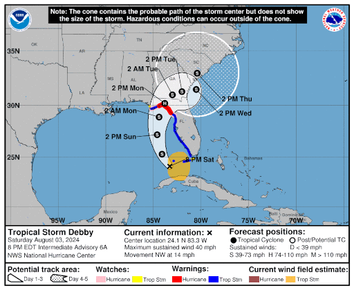
August 3, 2024 Comments Off on Probable Track


