Nicole Wind Field 11/8

At Noon CST Nicole is beginning to spin up. The barometric pressure is already low enough for a hurricane. (The times on the graphic are Eastern Standard Time)
Get out and vote, you have time.
November 8, 2022 2 Comments
Tropical Storm Nicole – Day 2
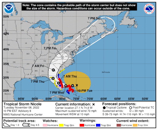
 Position: 27.1N 74.8W [ 9:00PM CST 0300UTC].
Movement: West-Southwest [250°] near 10 mph [17 kph].
Maximum sustained winds: 70 mph [110 kph].
Wind Gusts: 80 mph [130 kph].
Tropical Storm Wind Radius: 380 mph [610 kph].
Minimum central pressure: 984 mb.
Currently about 325 miles [ 525 km] East of West Palm Beach, Florida.
A Hurricane Warning is in effect for the Northwest Bahamas, including the Abacos, Berry Islands,Bimini, & Grand Bahama Island; Boca Raton to Flagler/Volusia County Line, Florida.
A Tropical Storm Warning is in effect for Andros Island, New Providence, & Eleuthera; Hallandale Beach, Florida to Boca Raton, Florida; Flagler/Volusia County Line, Florida to Altamaha Sound, Georgia; Lake Okeechobee.
A Storm Surge Warning is in effect for North Palm Beach, Florida to Altamaha Sound; Mouth of the St. Johns River to Georgetown, Florida.
A Hurricane Watch is in effect for the Coast of Florida from Hallandale Beach to Boca Raton, Florida; Flagler/Volusia County Line to Ponte Vedra Beach; Lake Okeechobee.
A Tropical Storm Watch is in effect for Hallandale Beach to north of Ocean Reef, Florida; North of Bonita Beach to the Ochlockonee River, Florida; north of Altamaha Sound, Georgia to South Santee River, South Carolina.
A Storm Surge Watch is in effect for North Palm Beach to Hallandale Beach, Florida; Altamaha Sound, Georgia to South Santee River, South Carolina; Anclote River, Florida to Indian Pass, Florida.
Here’s the link for NOAA’s latest satellite images.
[For the latest information click on the storm symbol, or go to the CATEGORIES drop-down box below the CALENDAR and select “Hurricanes” for all of the posts related to storms on this site.]
November 8, 2022 Comments Off on Tropical Storm Nicole – Day 2


