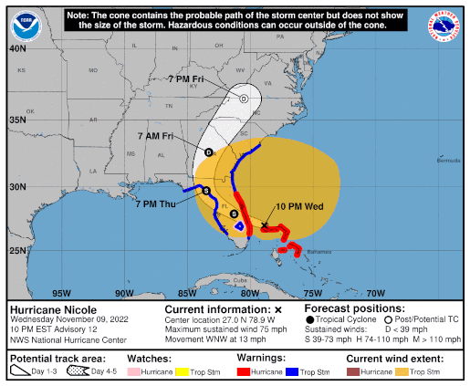
Nicole Wind Field 11/9

This storm has a huge wind field, the biggest I remember for a Florida storm since I’ve been tracking them (1995 onward)
At Noon CST the center was over Great Abaco Island
The 6PM CST update for the map is wrong. I’ll post when it’s corrected.
November 9, 2022 Comments Off on Nicole Wind Field 11/9
Hurricane Nicole – Day 3
 Position: 27.0N 78.9W [ 9:00PM CST 0300UTC].
Movement: West-Northwest [285°] near 13 mph [20 kph].
Maximum sustained winds: 75 mph [120 kph].
Wind Gusts: 90 mph [145 kph].
Tropical Storm Wind Radius: 485 mph [780 kph].
Hurricane Wind Radius: 25 miles [ 35 km].
Minimum central pressure: 980 mb;.
Currently about 20 miles [ 35 km] North-Northeast of Settlement Point, Grand Bahama Island.
Currently about 75 miles [ 125 km] East-Northeast of West Palm Beach, Florida.
A Hurricane Warning is in effect for the Northwest Bahamas, including the Abacos, Berry Islands, & Grand Bahama Island; Boca Raton to Flagler/Volusia County Line, Florida.
A Tropical Storm Warning is in effect for Bimini in the northwestern Bahamas; Hallandale Beach, Florida to Boca Raton, Florida; Flagler/Volusia County Line, Florida to South Santee River, South Carolina; North of Bonita Beach to Indian Pass, Florida; Lake Okeechobee.
A Storm Surge Warning is in effect for North Palm Beach, Florida to Altamaha Sound, Georgia; Mouth of the St. Johns River to Georgetown, Florida.
A Hurricane Watch is in effect for Lake Okeechobee.
A Storm Surge Watch is in effect for North Palm Beach to Hallandale Beach, Florida; Altamaha Sound, Georgia to South Santee River, South Carolina; Anclote River, Florida to Indian Pass, Florida.
Here’s the link for NOAA’s latest satellite images.
[For the latest information click on the storm symbol, or go to the CATEGORIES drop-down box below the CALENDAR and select “Hurricanes” for all of the posts related to storms on this site.]
November 9, 2022 Comments Off on Hurricane Nicole – Day 3


