Category — Hurricanes
Tropical Storm Bret – Day 3
 Position: 13.5N 55.2W [10:00PM CDT 0300UTC].
Movement: West [280°] near 16 mph [26 kph].
Maximum sustained winds: 65 mph [100 kph].
Wind Gusts: 75 mph [120 kph].
Tropical Storm Wind Radius: 115 miles [185 km].
Minimum central pressure: 1000 mb.
Currently about 290 miles [ 465 km] East of Barbados.
A Tropical Storm Warning is in effect for St. Lucia, Martinique, and Dominica.
A Tropical Storm Watch is in effect for Barbados and St. Vincent & the Grenadines.
Here’s the link for NOAA’s latest satellite images.
[For the latest information click on the storm symbol, or go to the CATEGORIES drop-down box below the CALENDAR and select “Hurricanes” for all of the posts related to storms on this site.]
June 21, 2023 Comments Off on Tropical Storm Bret – Day 3
Tropical Storm Bret – Day 2
 Position: 12.5N 50.2W [10:00PM CDT 0300UTC].
Movement: West [280°] near 17 mph [28 kph].
Maximum sustained winds: 50 mph [ 85 kph].
Wind Gusts: 60 mph [ 95 kph].
Tropical Storm Wind Radius: 45 miles [ 75 km].
Minimum central pressure: 1003 mb ↓.
Currently about 730 miles [1170 km] East of the Windward Islands.
A Tropical Storm Watch is in effect for Barbados, Dominica, St. Lucia, and Martinique.
Here’s the link for NOAA’s latest satellite images.
[For the latest information click on the storm symbol, or go to the CATEGORIES drop-down box below the CALENDAR and select “Hurricanes” for all of the posts related to storms on this site.]
June 20, 2023 Comments Off on Tropical Storm Bret – Day 2
Tropical Storm Bret
 Position: 11.4N 43.5W [10:00PM CDT 0300UTC].
Movement: West [275°] near 18 mph [30 kph].
Maximum sustained winds: 40 mph [ 65 kph].
Wind Gusts: 50 mph [ 80 kph].
Tropical Storm Wind Radius: 45 miles [ 75 km].
Minimum central pressure: 1008 mb.
Currently about 1210 miles [1945 km] East of the Southern Windward Islands.
Here’s the link for NOAA’s latest satellite images.
[For the latest information click on the storm symbol, or go to the CATEGORIES drop-down box below the CALENDAR and select “Hurricanes” for all of the posts related to storms on this site.]
June 19, 2023 Comments Off on Tropical Storm Bret
Remnant Low Arlene – Day 3
 Position: 23.7N 84.7W [ 4:00PM CDT 2100UTC].
Movement: South-Southeast [150°] near 7 mph [11 kph].
Maximum sustained winds: 30 mph [ 45 kph].
Wind Gusts: 40 mph [ 65 kph].
Minimum central pressure: 1001 mb ↑.
Currently about 135 miles [ 215 km] West-Southwest of the Dry Tortugas.
This is the last public advisory issued by the National Hurricane Center on this system.
Here’s the link for NOAA’s latest satellite images.
[For the latest information click on the storm symbol, or go to the CATEGORIES drop-down box below the CALENDAR and select “Hurricanes” for all of the posts related to storms on this site.]
June 3, 2023 Comments Off on Remnant Low Arlene – Day 3
Tropical Storm Arlene – Day 2
 Position: 25.4N 85.5W [10:00PM CDT 0300UTC].
Movement: South-Southeast [155°] near 7 mph [11 kph].
Maximum sustained winds: 40 mph [ 65 kph].
Wind Gusts: 50 mph [ 80 kph].
Tropical Storm Wind Radius: 70 miles [110 kmh].
Minimum central pressure: 998 mb ↓.
Currently about 170 miles [ 275 km] West-Northwest of the Dry Tortugas.
Here’s the link for NOAA’s latest satellite images.
[For the latest information click on the storm symbol, or go to the CATEGORIES drop-down box below the CALENDAR and select “Hurricanes” for all of the posts related to storms on this site.]
June 2, 2023 Comments Off on Tropical Storm Arlene – Day 2
Tropical Depression Two
 Position: 27.5N 86.5W [10:00PM CDT 0300UTC].
Movement: South [180°] near 3 mph [ 6 kph].
Maximum sustained winds: 35 mph [ 55 kph].
Wind Gusts: 45 mph [ 75 kph].
Minimum central pressure: 1007 mb.
Currently about 290 miles [ 465 km] West-Northwest of Fort Myers, Florida.
Here’s the link for NOAA’s latest satellite images.
[For the latest information click on the storm symbol, or go to the CATEGORIES drop-down box below the CALENDAR and select “Hurricanes” for all of the posts related to storms on this site.]
June 1, 2023 Comments Off on Tropical Depression Two
2022 Hurricane
- TS Alex 5-6 Jun 70
- TS Bonnie 1-9 Jul 115
- TS Colin 1-2 Jul 40
- H Danielle 1-8 Sep 90
- H Earl 3-10 Sep 105
- MH Fiona 14-24 Sep 130
- TS Gaston 20-26 Sep 65
- MH Ian 23-30 Sep 155
- TS Hermine 23-25 Sep 40
- TD Eleven 28-29 Sep 35
- TD Twelve 4-5 Oct 35
- H Julia 6-9 Oct 85
- TS Karl 11-15 Oct 60
- H Lisa 31 Oct-5 Nov 85
- H Martin 1-3 Nov 85
- H Nicole 7-11 Nov 75
(TD – Tropical Depression; TS – Tropical Storm; H – Hurricane; MH – Major Hurricane)
The NHC summary of US landfalls:
The 2022 season saw three hurricane landfalls along the coast of the U.S. mainland. Hurricane Ian made landfall first as a Category 4 storm in Cayo Costa, Florida, and again as a Category 1 in Georgetown, South Carolina. As a Category 4 with 150 mph maximum sustained winds, Hurricane Ian tied for the fifth-strongest hurricane ever to make landfall in the U.S. Hurricane Nicole made landfall as a Category 1 in north Hutchinson Island, Florida.
Hurricane Fiona made landfall outside of the mainland U.S. as a Category 1 near Punta Tocon, Puerto Rico.
Tropical Storm Bonnie made landfall at the Nicaragua/Costa Rica border and continued across to the Pacific Ocean where it became a 115mph Hurricane.
December 3, 2022 Comments Off on 2022 Hurricane
Tropical Depression Nicole – Day 5
 Position: 34.3N 84.3W [ 9:00AM CST 1500UTC].
Movement: North-Northeast [015°] near 23 mph [37 kph].
Maximum sustained winds: 30 mph [ 45 kph].
Wind Gusts: 40 mph [ 65 kph].
Minimum central pressure: 1001 mb ↑.
Currently about 35 miles [ 55 km] North of Atlanta, Georgia.
This is the last public advisory issued by the National Hurricane Center on this system.
Here’s the link for NOAA’s latest satellite images.
[For the latest information click on the storm symbol, or go to the CATEGORIES drop-down box below the CALENDAR and select “Hurricanes” for all of the posts related to storms on this site.]
November 11, 2022 Comments Off on Tropical Depression Nicole – Day 5
Nicole Wind Field 11/10

November 10, 2022 Comments Off on Nicole Wind Field 11/10
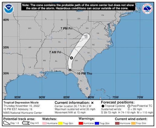
Tropical Depression Nicole – Day 4
 Position: 30.7N 84.3W [ 9:00PM CST 0300UTC].
Movement: Northwest [320°] near 15 mph [24 kph].
Maximum sustained winds: 35 mph [ 55 kph].
Wind Gusts: 45 mph [ 70 kph].
Minimum central pressure: 992 mb ↑.
Currently about 20 miles [ 35 km] North of Tallahassee, Florida.
Here’s the link for NOAA’s latest satellite images.
[For the latest information click on the storm symbol, or go to the CATEGORIES drop-down box below the CALENDAR and select “Hurricanes” for all of the posts related to storms on this site.]
November 10, 2022 Comments Off on Tropical Depression Nicole – Day 4
Nicole Wind Field 11/9

This storm has a huge wind field, the biggest I remember for a Florida storm since I’ve been tracking them (1995 onward)
At Noon CST the center was over Great Abaco Island
The 6PM CST update for the map is wrong. I’ll post when it’s corrected.
November 9, 2022 Comments Off on Nicole Wind Field 11/9
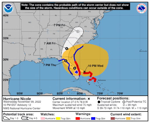
Hurricane Nicole – Day 3
 Position: 27.0N 78.9W [ 9:00PM CST 0300UTC].
Movement: West-Northwest [285°] near 13 mph [20 kph].
Maximum sustained winds: 75 mph [120 kph].
Wind Gusts: 90 mph [145 kph].
Tropical Storm Wind Radius: 485 mph [780 kph].
Hurricane Wind Radius: 25 miles [ 35 km].
Minimum central pressure: 980 mb;.
Currently about 20 miles [ 35 km] North-Northeast of Settlement Point, Grand Bahama Island.
Currently about 75 miles [ 125 km] East-Northeast of West Palm Beach, Florida.
A Hurricane Warning is in effect for the Northwest Bahamas, including the Abacos, Berry Islands, & Grand Bahama Island; Boca Raton to Flagler/Volusia County Line, Florida.
A Tropical Storm Warning is in effect for Bimini in the northwestern Bahamas; Hallandale Beach, Florida to Boca Raton, Florida; Flagler/Volusia County Line, Florida to South Santee River, South Carolina; North of Bonita Beach to Indian Pass, Florida; Lake Okeechobee.
A Storm Surge Warning is in effect for North Palm Beach, Florida to Altamaha Sound, Georgia; Mouth of the St. Johns River to Georgetown, Florida.
A Hurricane Watch is in effect for Lake Okeechobee.
A Storm Surge Watch is in effect for North Palm Beach to Hallandale Beach, Florida; Altamaha Sound, Georgia to South Santee River, South Carolina; Anclote River, Florida to Indian Pass, Florida.
Here’s the link for NOAA’s latest satellite images.
[For the latest information click on the storm symbol, or go to the CATEGORIES drop-down box below the CALENDAR and select “Hurricanes” for all of the posts related to storms on this site.]
November 9, 2022 Comments Off on Hurricane Nicole – Day 3
Nicole Wind Field 11/8

At Noon CST Nicole is beginning to spin up. The barometric pressure is already low enough for a hurricane. (The times on the graphic are Eastern Standard Time)
Get out and vote, you have time.
November 8, 2022 2 Comments
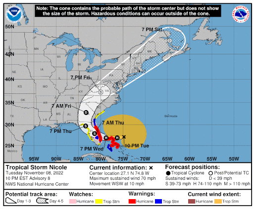
Tropical Storm Nicole – Day 2
 Position: 27.1N 74.8W [ 9:00PM CST 0300UTC].
Movement: West-Southwest [250°] near 10 mph [17 kph].
Maximum sustained winds: 70 mph [110 kph].
Wind Gusts: 80 mph [130 kph].
Tropical Storm Wind Radius: 380 mph [610 kph].
Minimum central pressure: 984 mb.
Currently about 325 miles [ 525 km] East of West Palm Beach, Florida.
A Hurricane Warning is in effect for the Northwest Bahamas, including the Abacos, Berry Islands,Bimini, & Grand Bahama Island; Boca Raton to Flagler/Volusia County Line, Florida.
A Tropical Storm Warning is in effect for Andros Island, New Providence, & Eleuthera; Hallandale Beach, Florida to Boca Raton, Florida; Flagler/Volusia County Line, Florida to Altamaha Sound, Georgia; Lake Okeechobee.
A Storm Surge Warning is in effect for North Palm Beach, Florida to Altamaha Sound; Mouth of the St. Johns River to Georgetown, Florida.
A Hurricane Watch is in effect for the Coast of Florida from Hallandale Beach to Boca Raton, Florida; Flagler/Volusia County Line to Ponte Vedra Beach; Lake Okeechobee.
A Tropical Storm Watch is in effect for Hallandale Beach to north of Ocean Reef, Florida; North of Bonita Beach to the Ochlockonee River, Florida; north of Altamaha Sound, Georgia to South Santee River, South Carolina.
A Storm Surge Watch is in effect for North Palm Beach to Hallandale Beach, Florida; Altamaha Sound, Georgia to South Santee River, South Carolina; Anclote River, Florida to Indian Pass, Florida.
Here’s the link for NOAA’s latest satellite images.
[For the latest information click on the storm symbol, or go to the CATEGORIES drop-down box below the CALENDAR and select “Hurricanes” for all of the posts related to storms on this site.]
November 8, 2022 Comments Off on Tropical Storm Nicole – Day 2


