
Tropical Depression Thirteen
 Position: 11.9 69.8W [10:00PM CDT 0300UTC].
Movement: West [280°] near 15 mph [24 kph].
Maximum sustained winds: 35 mph [ 55 kph].
Wind Gusts: 45 mph [ 70 kph].
Minimum central pressure: 1004 mb ↑.
Currently about 120 miles [ 195 km] East-Southeast of the northern tip of Guajira Peninsula, Colombia.
A Tropical Storm Warning is in effect for the coast of Colombia from Riohacha eastward to the Colombia/Venezuela border.
A Hurricane Watch is in effect for the San Andres, Providencia, and Santa Catalina Islands, Colombia.
Here’s the link for NOAA’s latest satellite images.
[For the latest information click on the storm symbol, or go to the CATEGORIES drop-down box below the CALENDAR and select “Hurricanes” for all of the posts related to storms on this site.]
October 6, 2022 Comments Off on Tropical Depression Thirteen
Remnant Twelve – Day 3
 Position: 18.6N 36.8W [10:00PM CDT 0300UTC].
Movement: West-Northwest [290°] near 17 mph [28 kph].
Maximum sustained winds: 35 mph [ 55 kph].
Wind Gusts: 45 mph [ 70 kph].
Minimum central pressure: 1010 mb ↑.
Currently about 860 miles [1390 km] West-Northwest of the Cabo Verde Islands..
This is the last public advisory issued by the National Hurricane Center on this system.
Here’s the link for NOAA’s latest satellite images.
[For the latest information click on the storm symbol, or go to the CATEGORIES drop-down box below the CALENDAR and select “Hurricanes” for all of the posts related to storms on this site.]
October 6, 2022 Comments Off on Remnant Twelve – Day 3
Tropical Depression Twelve – Day 2
Position: 17.7N 32.5W [10:00PM CDT 0300UTC].
Movement: Northwest [320°] near 10 mph [17 kph].
Maximum sustained winds: 35 mph [ 55 kph].
Wind Gusts: 45 mph [ 70 kph].
Minimum central pressure: 1006 mb ↓.
Currently about 575 miles [ 925 km] West-Northwest of the Cabo Verde Islands.
Here’s the link for NOAA’s latest satellite images.
[For the latest information click on the storm symbol, or go to the CATEGORIES drop-down box below the CALENDAR and select “Hurricanes” for all of the posts related to storms on this site.]
October 5, 2022 Comments Off on Tropical Depression Twelve – Day 2
Tropical Depression Twelve
Position: 15.3N 30.4W [10:00PM CDT 0300UTC].
Movement: North-Northwest [335°] near 9 mph [15 kph].
Maximum sustained winds: 35 mph [ 55 kph].
Wind Gusts: 45 mph [ 70 kph].
Minimum central pressure: 1007 mb.
Currently about 430 miles [ 690 km] West of the Cabo Verde Islands
Here’s the link for NOAA’s latest satellite images.
[For the latest information click on the storm symbol, or go to the CATEGORIES drop-down box below the CALENDAR and select “Hurricanes” for all of the posts related to storms on this site.]
October 4, 2022 Comments Off on Tropical Depression Twelve
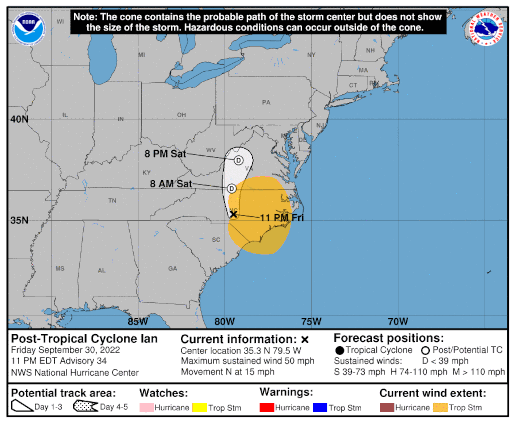
Post-Tropical Cyclone Ian – Day 9
 Position: 35.7N 79.8W [ 4:00AM CDT 0900UTC].
Movement: North-Northwest [345°] near 12 mph [19 kph].
Maximum sustained winds: 35 mph [ 55 kph].
Wind Gusts: 40 mph [ 65 kph].
Minimum central pressure: 1001 mb ↑.
Currently about 30 miles [ 45 km] South of Greensboro, North Carolina.
This is the final public advisory issued by the National Hurricane Center on this system.
Here’s the link for NOAA’s latest satellite images.
[For the latest information click on the storm symbol, or go to the CATEGORIES drop-down box below the CALENDAR and select “Hurricanes” for all of the posts related to storms on this site.]
October 1, 2022 1 Comment
Ian Wind Field 9/30
September 30, 2022 Comments Off on Ian Wind Field 9/30
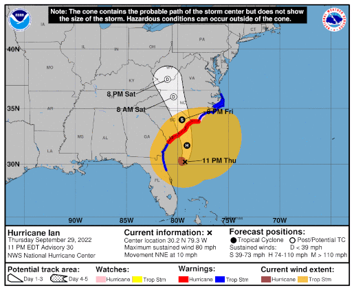
Post-Tropical Cyclone Ian – Day 8
Position: 35.3N 79.5W [10:00PM CDT 0300UTC].
Movement: North [350°] near 15 mph [24 kph].
Maximum sustained winds: 50 mph [ 85 kph].
Wind Gusts: 60 mph [ 95 kph].
Tropical Storm Wind Radius: 195 miles [315 km].
Minimum central pressure: 994 mb ↑.
Currently about 60 miles [ 95 km] South-Southeast of Greensboro, North Carolina.
At 1PM CDT Ian is beginning its second landfall in the US.
Here’s the link for NOAA’s latest satellite images.
[For the latest information click on the storm symbol, or go to the CATEGORIES drop-down box below the CALENDAR and select “Hurricanes” for all of the posts related to storms on this site.]
September 30, 2022 Comments Off on Post-Tropical Cyclone Ian – Day 8
Remnant Eleven – Day 2
Position: 19.1 37.4W [ 4:00PM CDT 2100UTC].
Movement: Northwest [320°] near 14 mph [22 kph].
Maximum sustained winds: 30 mph [ 45 kph].
Wind Gusts: 40 mph [ 65 kph].
Minimum central pressure: 1010 mb ↑.
Currently about 950 miles [1530 km] West-Northwest of the Cabo Verde Islands.
This is the final public advisory issued by the National Hurricane Center on this system.
Here’s the link for NOAA’s latest satellite images.
[For the latest information click on the storm symbol, or go to the CATEGORIES drop-down box below the CALENDAR and select “Hurricanes” for all of the posts related to storms on this site.]
September 29, 2022 Comments Off on Remnant Eleven – Day 2
Ian Wind Field 9/29
September 29, 2022 Comments Off on Ian Wind Field 9/29
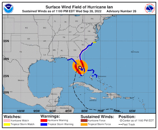
Hurricane Ian – Day 7
 Position: 30.2N 79.3W [10:00PM [CDT 0300UTC].
Movement: North-Northeast [030°] near 10 mph [17 kph].
Maximum sustained winds: 80 mph [130 kph].
Wind Gusts: 95 mph [155 kph].
Tropical Storm Wind Radius: 415 miles [665 km].
Hurricane Wind Radius: 45 miles [ 75 km].
Minimum central pressure: 986 mb.
Currently about 185 miles [ 295 km] South of Charleston, South Carolina.
Currently about 265 miles [ 430 km] South-Southwest of Cape Fear, North Carolina.
A Hurricane Warning is in effect for the Savannah River to Cape Fear.
A Tropical Storm Warning is in effect for the Flagler/Volusia County Line to Savannah River; Cape Fear to Duck, North Carolina; Pamlico Sound.
A Storm Surge Warning is in effect for the Flagler/Volusia Line to Cape Fear; St. Johns River; Neuse River.
A Hurricane Watch is in effect for East of Cape Fear to Surf City.
A Storm Surge Watch is in effect for North of Cape Fear to Duck, North Carolina; Pamlico River; Cape Fear River.
Here’s the link for NOAA’s latest satellite images.
[For the latest information click on the storm symbol, or go to the CATEGORIES drop-down box below the CALENDAR and select “Hurricanes” for all of the posts related to storms on this site.]
September 29, 2022 Comments Off on Hurricane Ian – Day 7
Tropical Depression Eleven
Position: 17.2N 35.6W [10:00PM CDT 0300UTC].
Movement: North-Northwest [345°] near 10 mph [17 kph].
Maximum sustained winds: 35 mph [ 55 kph].
Wind Gusts: 45 mph [ 70 kph].
Minimum central pressure: 1008.
Currently about 770 miles [1240 km] West of the Cabo Verde Islands.
Here’s the link for NOAA’s latest satellite images.
[For the latest information click on the storm symbol, or go to the CATEGORIES drop-down box below the CALENDAR and select “Hurricanes” for all of the posts related to storms on this site.]
September 28, 2022 Comments Off on Tropical Depression Eleven
Ian Wind Field 9/28
September 28, 2022 Comments Off on Ian Wind Field 9/28
Hurricane Ian – Day 6
Position: 27.5N 81.4W [10:00PM [CDT 0300UTC].
Movement: North-Northeast [030°] near 8 mph [13 kph].
Maximum sustained winds: 90 mph [150 kph].
Wind Gusts: 105 mph [170 kph].
Tropical Storm Wind Radius: 175 miles [280 km].
Hurricane Wind Radius: 45 miles [ 75 km].
Minimum central pressure: 972 mb ↑.
Currently about 70 miles [ 150 km] South of Orlando, Florida.
Currently about 80 miles [ 110 km] Southwest of Cape Canaveral, Florida.
At 3:35PM CDT Ian made landfall between Fort Myers and Punta Gorda as a Category 4 storm with 145 mph sustained winds.
This is very bad for South Florida. A Category 4 landfall and the storm surge will be another Hurricane Andrew in effect.
A Hurricane Warning is in effect for Chokoloskee to the Anclote River, including Tampa Bay; Sebastian Inlet to Flagler/Volusia County Line.
A Tropical Storm Warning is in effect for Indian Pass to the Anclote River; Flamingo to Sebastian Inlet; Flamingo to Chokoloskee ;Flagler/Volusia County Line to Surf City; Lake Okeechobee; Bimini and Grand Bahama Islands.
A Storm Surge Warning is in effect for the Suwanee River southward to Flamingo; Tampa Bay; Flagler/Volusia Line to the mouth of the South Santee River; St. Johns River.
A Hurricane Watch is in effect for Flagler/Volusia County Line to the South Santee River.
A Tropical Storm Watch is in effect for North of Surf City to Cape Lookout.
A Storm Surge Watch is in effect for North of South Santee River to Little River Inlet.
Here’s the link for NOAA’s latest satellite images.
[For the latest information click on the storm symbol, or go to the CATEGORIES drop-down box below the CALENDAR and select “Hurricanes” for all of the posts related to storms on this site.]
September 28, 2022 Comments Off on Hurricane Ian – Day 6
Hurricane Ian – Day 5
 Position: 24.9N 82.9W [10:00PM [CDT 0300UTC].
Movement: North-Northeast [015°] near 10 mph [17 kph].
Maximum sustained winds: 120 mph [195 kph].
Wind Gusts: 140 mph [225 kph].
Tropical Storm Wind Radius: 140 miles [220 km].
Hurricane Wind Radius: 40 miles [ 65 km].
Minimum central pressure: 952 mb ↑.
Currently about 110 miles [ 175 km] Southwest of Naples, Florida.
A Hurricane Warning is in effect for Chokoloskee to the Anclote River, including Tampa Bay; Dry Tortugas.
A Tropical Storm Warning is in effect for the Cuban provinces of Isla de Juventud, Pinar del Rio, Artemisa, La Habana, Mayabeque, and Matanzas; Suwannee River to the Anclote River; Flamingo to South Santee River; Flamingo to Chokoloskee; All of the Florida Keys; Lake Okeechobee; Florida Bay; Bimini and Grand Bahama Islands.
A Storm Surge Warning is in effect for the Suwanee River southward to Flamingo; Tampa Bay; Dry Tortugas; Flagler/Volusia Line to the mouth of the St. Mary’s River; St. Johns River.
A Storm Surge Watch is in effect for the Florida Keys from the Card Sound Bridge westward to Key West; Florida Bay; Mouth of St. Mary’s River to South Santee River; South of Marineland to the Volusia/Flagler county line.
[For the latest information click on the storm symbol, or go to the CATEGORIES drop-down box below the CALENDAR and select “Hurricanes” for all of the posts related to storms on this site.]
September 27, 2022 Comments Off on Hurricane Ian – Day 5


