Posts from — September 2008
Are We Having Fun Yet?
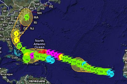
Screenshot of the Atlantic Basin on Weather Underground‘s Wundermap with all three storms and their tracks. Click on the map to go to the site.
September 4, 2008 7 Comments
Tropical Storm Hanna
 Position: 26.5 N 76.3 W. [10 PM CDT]
Movement: Northwest [320°] near 14 mph.
Maximum sustained winds: 65 mph.
Wind Gusts: 75 mph.
Tropical Storm Wind Radius: 315 miles.
Minimum central pressure: 987 mb.
It is 540 miles South of Wilmington, North Carolina.
September 4, 2008 Comments Off on Tropical Storm Hanna
Obersturmfury Ike – Category 4
 Position: 23.6 N 59.5 W. [10 PM CDT]
Movement: West_Northwest [275°] near 14 mph.
Maximum sustained winds: 135 mph.
Wind Gusts: 160 mph.
Hurricane Wind Radius: 45 miles.
Tropical Storm Wind Radius: 140 miles.
Minimum central pressure: 945 mb.
It is about 475 miles North-Northeast of the Leeward Islands.
Note that Ike went from a 70 mph tropical storm to a 135 mph Category 4 hurricane in under 12 hours yesterday. [Hurricane records are recorded in 6-hour increments] and it wasn’t forecast. It would be nice if we had some more satellites over the Atlantic Basin to watch these storms, but some people think that wars and manned missions to the moon are more important.
September 4, 2008 2 Comments
Tropical Storm Josephine
 Position: 15.1 N 33.8 W. [10 PM CDT]
Movement: West-Northwest [290°] near 10 mph.
Maximum sustained winds: 45 mph.
Wind Gusts: 55 mph.
Tropical Storm Wind Radius: 175 miles.
Minimum central pressure: 1002 mb.
It is 630 miles West of the Cape Verde Islands.
September 4, 2008 Comments Off on Tropical Storm Josephine
This Is Not Good
Not good at all. This was a nice little hurricane a few hours ago, and now it has a definite attitude. It’s a good thing that Al Gore needs to lose weight or some people might suspect that these explosive growth major hurricanes have something to do with global climate change.
September 3, 2008 15 Comments
Levee Problems Aren’t Restricted To NOLA
From the Miami Herald: Lake Okeechobee draining may have to start quickly:
The slow draining down of Lake Okeechobee could begin as early as Wednesday.
With three tropical systems looming in the Atlantic Ocean, the Army Corps of Engineers said Tuesday it hopes to begin slowing the lake’s record-setting rise — and lowering the potential risk to its aging levee.
The level of the lake had been so low that there were fires in the lake bed earlier this year, but Tropical Storm Fay has more than re-filled the lake and the huge size of Hanna guarantees that more water is coming.
At least the Everglades are getting a decent drink, but if the lake fills too quickly, the 70-year-old Herbert Hoover Dike may not stand up to the strain. The levees were built following the 1928 hurricane that passed over the lake resulting in more than 1,800 deaths from the flooding.
There is also the problem caused by the burrowing of the South American sailfin catfish, one of our many invasive species.
But, other than that, No Problems 😈
September 3, 2008 12 Comments
Not A Beach Weekend
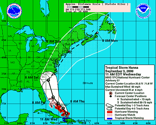
If you live along or near the Atlantic Coast, you might want to rethink your plans for the weekend. This is the current National Hurricane Center forecast path for Tropical Storm Hanna.
September 3, 2008 2 Comments
Tropical Storm Hanna
 Position: 23.7 N 72.4 W. [1 AM CDT]
Movement: North-Northwest [335°] near 13 mph.
Maximum sustained winds: 65 mph.
Wind Gusts: 75 mph.
Tropical Storm Wind Radius: 290 miles.
Minimum central pressure: 989 mb.
It is 325 miles East-Southeast of Nassau.
September 3, 2008 Comments Off on Tropical Storm Hanna
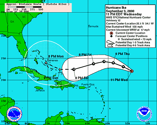
Obersturmfury Ike – Category 4
 Position: 22.1 N 54.1 W. [10 PM CDT]
Movement: West_Northwest [295°] near 17 mph.
Maximum sustained winds: 135 mph.
Wind Gusts: 160 mph.
Hurricane Wind Radius: 35 miles.
Tropical Storm Wind Radius: 160 miles.
Minimum central pressure: 948 mb.
It is about 610 miles East-Northeast of the Leeward Islands.
It is growing by leaps and bounds. Hopefully it will calm down before getting near land.
September 3, 2008 Comments Off on Obersturmfury Ike – Category 4
Tropical Storm Josephine
 Position: 13.9 N 30.7 W. [10 PM CDT]
Movement: West [275°] near 12 mph.
Maximum sustained winds: 50 mph.
Wind Gusts: 65 mph.
Tropical Storm Wind Radius: 105 miles.
Minimum central pressure: 1000 mb.
It is 425 miles West of the Cape Verde Islands.
The storm is weakening.
September 3, 2008 Comments Off on Tropical Storm Josephine
Tropical Storm Hanna
 Position: 20.5 N 72.4 W. [10 PM CDT]
Movement: Stationary.
Maximum sustained winds: 65 mph.
Wind Gusts: 75 mph.
Tropical Storm Wind Radius: 200 miles.
Minimum central pressure: 988 mb.
It is 65 miles Southeast of Great Inagua Island.
It is looping in place.
September 2, 2008 4 Comments
Tropical Storm Ike
 Position: 19.9 N 47.9 W. [10 PM CDT]
Movement: West_Northwest [285°] near 17 mph.
Maximum sustained winds: 65 mph.
Wind Gusts: 75 mph.
Tropical Storm Wind Radius: 140 miles.
Minimum central pressure: 996 mb.
It is about 930 miles East-Northeast of the Leeward Islands.
September 2, 2008 Comments Off on Tropical Storm Ike
Tropical Depression Gustav
Position: 31.7 N 93.4 W. [4 AM CDT]
Movement: Northwest [315°] near 10 mph.
Maximum sustained winds: 35 mph.
Wind Gusts: 45 mph.
Minimum central pressure: 985 mb.
It is 135 miles Northwest of Lafayette, Louisiana.
This is the final advisory from the Hurricane Center for Gustav
September 2, 2008 Comments Off on Tropical Depression Gustav
Tropical Storm Josephine
 Position: 13.6 N 26.8 W. [10 PM CDT]
Movement: West-Northwest [280°] near 12 mph.
Maximum sustained winds: 50 mph.
Wind Gusts: 65 mph.
Tropical Storm Wind Radius: 85 miles.
Minimum central pressure: 1000 mb.
It is 180 miles West-Southwest of the Cape Verde Islands.
This was Tropical Depression Ten.
September 2, 2008 Comments Off on Tropical Storm Josephine


