
Posts from — September 2017
Tropical Depression Fourteen
 Position: 12.8N 30.7W [10PM CDT 0300 UTC].
Movement: West [280°] near 10 mph [17 kph].
Maximum sustained winds: 35 mph [ 55 kph].
Wind Gusts: 50 mph [ 80 kph].
Minimum central pressure: 1009 mb.
Currently about 500 miles [805 km] West-Southwest of the Cabo Verde Islands.
Here’s the link for NOAA’s latest satellite images.
[For the latest information click on the storm symbol, or go to the CATEGORIES drop-down box below the CALENDAR and select “Hurricanes” for all of the posts related to storms on this site.]
September 15, 2017 Comments Off on Tropical Depression Fourteen
Hurricane Jose – Day 11
 Position: 27.4N 71.0W [10PM CDT 0300 UTC].
Movement: Northwest [305°] near 9 mph [15 kph].
Maximum sustained winds: 80 mph [130 kph].
Wind Gusts: 100 mph [160 kph].
Tropical Storm Wind Radius: 150 miles [240 km].
Hurricane Wind Radius: 35 miles [ 55 km].
Minimum central pressure: 983 mb.
Currently about 600 miles [ 965 km] South-Southeast of the Cape Hatteras, North Carolina.
Here’s the link for NOAA’s latest satellite images.
[For the latest information click on the storm symbol, or go to the CATEGORIES drop-down box below the CALENDAR and select “Hurricanes” for all of the posts related to storms on this site.]
September 15, 2017 Comments Off on Hurricane Jose – Day 11
Holy Pasta Week

The Day of His Noodly Appendage
The holiest of holidays for Pastafarians, is of course the birthday of His Most Holy Prophet, Marco Polo (b. Sept 15, 1254), who brought the word of his Noodly Appendage back from the East. As Talk Like A Pirate Day falls on September 19th, this five-day period constitutes Holy Pasta Week, during which spaghetti is consumed liberally. With a nice Chianti until the last day when it’s grog for all.
September 15, 2017 2 Comments
Tropical Storm Jose – Day 10
 Position: 25.5N 68.0W [10PM CDT 0300 UTC].
Movement: West-Northwest [285°] near 8 mph [13 kph].
Maximum sustained winds: 70 mph [120 kph].
Wind Gusts: 90 mph [145 kph].
Tropical Storm Wind Radius: 140 miles [220 km].
Minimum central pressure: 989 mb.
Currently about 375 miles [ 605 km] Northeast of the Southeastern Bahamas.
Here’s the link for NOAA’s latest satellite images.
[For the latest information click on the storm symbol, or go to the CATEGORIES drop-down box below the CALENDAR and select “Hurricanes” for all of the posts related to storms on this site.]
September 14, 2017 Comments Off on Tropical Storm Jose – Day 10
Hurricane Jose – Day 9
Position: 25.2N 66.0W [10PM CDT 0300 UTC].
Movement: West [270°] near 3 mph [ 6 kph].
Maximum sustained winds: 80 mph [130 kph].
Wind Gusts: 95mph [155 kph].
Tropical Storm Wind Radius: 115 miles [185 km].
Hurricane Wind Radius: 25 miles [ 35 km].
Minimum central pressure: 985 mb.
Currently about 475 miles [ 765 km] East-Northeast of the Southeastern Bahamas.
Here’s the link for NOAA’s latest satellite images.
[For the latest information click on the storm symbol, or go to the CATEGORIES drop-down box below the CALENDAR and select “Hurricanes” for all of the posts related to storms on this site.]
September 13, 2017 Comments Off on Hurricane Jose – Day 9
Hurricane Jose – Day 8
Position: 26.5N 66.4W [10PM CDT 0300 UTC].
Movement: Southeast [125°] near 9 mph [15 kph].
Maximum sustained winds: 75 mph [120 kph].
Wind Gusts: 95mph [155 kph].
Tropical Storm Wind Radius: 140 miles [220 km].
Hurricane Wind Radius: 25 miles [ 35 km].
Minimum central pressure: 985 mb ↓.
Currently about 495 miles [ 800 km] North-Northeast of the Southeastern Bahamas.
Here’s the link for NOAA’s latest satellite images.
[For the latest information click on the storm symbol, or go to the CATEGORIES drop-down box below the CALENDAR and select “Hurricanes” for all of the posts related to storms on this site.]
September 12, 2017 Comments Off on Hurricane Jose – Day 8
Tropical Weather?
I had to get a blanket last night. At 10AM it was 62°. I do not appreciate having to wear socks and look for a hoodie at the beginning of September. Socks and hoodies are Central Standard Time, not Daylight Savings Time! I am supposed to be worrying about a tree falling on the house or a house falling on me, not hypothermia!
Trump and his cabinet can sit on a saguaro and rotate. Climate change is real; it is happening now; and it is the fault of everyone who fought against the reasonable program of Jimmy Carter to wean the US off fossil fuels.
September 11, 2017 2 Comments
In Memoriam
September 11th, 2001

In the intervening 16 years we have spent hundreds of billions of dollars, trampled on peoples rights, created huge new government bureaucracies, and can’t respond as well as the third world to a natural disaster.
It seems like we are constantly being told that every new group that appears anywhere is capable of another 9/11 attack, so what is the point if we are no safer?
Richard Clarke: “Your government failed you. Those entrusted with protecting you failed you. And I failed you. We tried hard. But that doesn’t matter, because we failed. And for that failure, I would ask, once all the facts are out, for your understanding and for your forgiveness.“
September 11, 2017 6 Comments
Tropical Depression Irma – Day 13
Position: 32.4N 84.9W [10PM CDT 0300 UTC].
Movement: Northwest [320°] near 15 mph [24 kph].
Maximum sustained winds: 35 mph [ 55 kph].
Wind Gusts: 50 mph [ 80 kph].
Minimum central pressure: 988 mb ↑.
Currently about 95 miles [150 km] South-Southwest of Atlanta, Georgia.
This is the final NHC advisory.
Here’s the link for NOAA’s latest satellite images.
[For the latest information click on the storm symbol, or go to the CATEGORIES drop-down box below the CALENDAR and select “Hurricanes” for all of the posts related to storms on this site.]
September 11, 2017 Comments Off on Tropical Depression Irma – Day 13
Hurricane Jose – Day 7
Position: 27.1N 69.5W [10PM CDT 0300 UTC].
Movement: Northeast [045°] near 6 mph [ 9 kph].
Maximum sustained winds: 85 mph [140 kph].
Wind Gusts: 110 mph [175 kph].
Tropical Storm Wind Radius: 140 miles [220 km].
Hurricane Wind Radius: 25 miles [ 35 km].
Minimum central pressure: 982 mb ↑.
Currently about 400 miles [ 645 km] North-Northeast of Grand Turk Island.
Here’s the link for NOAA’s latest satellite images.
[For the latest information click on the storm symbol, or go to the CATEGORIES drop-down box below the CALENDAR and select “Hurricanes” for all of the posts related to storms on this site.]
September 11, 2017 Comments Off on Hurricane Jose – Day 7
Why I Stayed
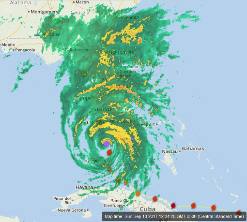
This is a screenshot of the Weather Underground’s WonderMap. I resized to fit in my blog window and added a purple dot to highlight the eye and a purple star to show Miami. I’m located about where the ‘s’ in Pensacola appears on the map. So far I’ve seen 25mph winds and cloudiness. They are forecasting rain tonight and/or tomorrow. Hurricanes aren’t circular, they are elliptical. The worst of the storm is in the Northeast quadrant. The winds move counterclockwise, they will be slowed by friction from the land before they get to me. If this had come into Mississippi or closer on the West side, I might not have hung around.
September 10, 2017 10 Comments
Hurricane Irma – Day 12
 Position: 27.5N 81.9W [10PM CDT 0300 UTC].
Movement: North [350°] near 14 mph [22 kph].
Maximum sustained winds: 100 mph [155 kph].
Wind Gusts: 130 mph [210 kph].
Tropical Storm Wind Radius: 415 miles [665 km].
Hurricane Wind Radius: 80 miles [130 km].
Minimum central pressure: 952 mb ↑.
Currently about 50 miles [ 80 km] Southeast of Tampa, Florida.
A Hurricane Warning is in effect for Fernandina North of Jupiter Inlet to Fernandina Beach; North of Bonita Beach to Indian Pass; Lake Okeechobee.
A Tropical Storm Warning is in effect for Jupiter Inlet southward around the Florida peninsula to Bonita Beach; Florida Keys; Florida Bay; West of Indian Pass to the Okaloosa/Walton County Line; North of Fernandina Beach to South Santee River.
A Storm Surge Warning is in effect for South Santee River southward to Jupiter Inlet; North Miami Beach southward around the Florida peninsula to the
Ochlockonee River; the Florida Keys; and Tampa Bay.
A Hurricane Watch is in effect for North of Fernandina Beach to Edisto Beach.
A Tropical Storm Watch is in effect for Bimini and Grand Bahama.
Here’s the link for NOAA’s latest satellite images.
[For the latest information click on the storm symbol, or go to the CATEGORIES drop-down box below the CALENDAR and select “Hurricanes” for all of the posts related to storms on this site.]
September 10, 2017 2 Comments
Hurricane Jose – Day 6
 Position: 23.7N 68.1W [10PM CDT 0300 UTC].
Movement: Northwest [325°] near 14 mph [22 kph].
Maximum sustained winds: 115 mph [185 kph].
Wind Gusts: 140 mph [225 kph].
Tropical Storm Wind Radius: 160 miles [260 km].
Hurricane Wind Radius: 35 miles [ 55 km].
Minimum central pressure: 962 mb ↑.
Currently about 245 miles [ 395 km] Northeast of Grand Turk Island.
Here’s the link for NOAA’s latest satellite images.
[For the latest information click on the storm symbol, or go to the CATEGORIES drop-down box below the CALENDAR and select “Hurricanes” for all of the posts related to storms on this site.]
September 10, 2017 Comments Off on Hurricane Jose – Day 6
Hurricane Irma – Day 11
Position: 23.5N 81.0W [10PM CDT 0300 UTC].
Movement: Northwest [305°] near 6 mph [ 9 kph].
Maximum sustained winds: 120 mph [195 kph].
Wind Gusts: 160 mph [255 kph].
Tropical Storm Wind Radius: 205 miles [335 km].
Hurricane Wind Radius: 70 miles [110 km].
Minimum central pressure: 933 mb ↑.
Currently about 90 miles [ 145 km] Southeast of Key West, Florida and about 30 miles [ 50 km] North-Northeast of Varadero, Cuba.
Interaction with Cuba is weakening Irma somewhat, but it is expected to re-intensify. At 4PM CDT the pressure is dropping indicating intensification.
A Hurricane Warning is in effect for Fernandina Beach southward around the Florida peninsula to Indian Pass; Florida Keys; Lake Okeechobee; Florida Bay; the Cuban provinces of Ciego de Avila, Sancti Spiritus, Villa Clara, Matanzas, & Havana; Andros Island, Bimini, and Grand Bahama.
A Tropical Storm Warning is in effect for West of Indian Pass to the Okaloosa/Walton County Line and North of Fernandina Beach to South Santee River.
A Storm Surge Warning is in effect for South Santee River southward to Jupiter Inlet; North Miami Beach southward around the Florida peninsula to the
Ochlockonee River; the Florida Keys; and Tampa Bay.
A Hurricane Watch is in effect for North of Fernandina Beach to Edisto Beach.
A Storm Surge Watch is in effect for North of the Suwanee River to Ochlockonee River.
Here’s the link for NOAA’s latest satellite images.
[For the latest information click on the storm symbol, or go to the CATEGORIES drop-down box below the CALENDAR and select “Hurricanes” for all of the posts related to storms on this site.]
September 9, 2017 4 Comments


