
Posts from — August 2023
Hurricane Franklin – Day 12
 Position: 36.8N 58.6W [10:00PM CDT 0300 UTC].
Movement: East-Northeast [060°] near 15 mph [24 kph].
Maximum sustained winds: 85 mph [140 kph].
Wind Gusts: 95 mph [155 kph].
Tropical Storm Wind Radius: 160 miles [260 km].
Hurricane Wind Radius: 60 miles [ 95 km].
Minimum central pressure: 979 mb ↑.
Currently about 470 miles [ 755 km] Northeast of Bermuda.
Here’s the link for NOAA’s latest satellite images.
[For the latest information click on the storm symbol, or go to the CATEGORIES drop-down box below the CALENDAR and select “Hurricanes” for all of the posts related to storms on this site.]
August 31, 2023 Comments Off on Hurricane Franklin – Day 12
Tropical Storm Jose – Day 3
 Position: 32.7N 52.4W [10:00PM CDT 0300 UTC].
Movement: North [355°] near 13 mph [20 kph].
Maximum sustained winds: 60 mph [ 95 kph].
Wind Gusts: 70 mph [110 kph].
Tropical Storm Wind Radius: 45 miles [ 75 km].
Minimum central pressure: 1002 mb ↓.
Currently about 720 miles [1160 km] East of Bermuda.
This was Tropical Depression Eleven. It is forecast to be absorbed by Franklin tomorrow.
Here’s the link for NOAA’s latest satellite images.
[For the latest information click on the storm symbol, or go to the CATEGORIES drop-down box below the CALENDAR and select “Hurricanes” for all of the posts related to storms on this site.]
August 31, 2023 Comments Off on Tropical Storm Jose – Day 3
Post-Tropical Cyclone Idalia – Day 6
 Position: 33.1N 71.5W [10:00PM CDT 0300 UTC].
Movement: East [095°] near 23 mph [37 kph].
Maximum sustained winds: 65 mph [100 kph].
Wind Gusts: 75 mph [120 kph].
Tropical Storm Wind Radius: 230 miles (370 km].
Minimum central pressure: 996 mb ↑.
Currently about 395 miles [ 635 km] West of Bermuda.
A Tropical Storm Watch is in effect for Bermuda.
Normally the NHC would stop tracking Idalia when it became post-tropical, but Bermuda declared a Tropical Storm Watch and Idalia is forecast to become tropical this weekend. This is the new normal – the weird.
Here’s the link for NOAA’s latest satellite images.
[For the latest information click on the storm symbol, or go to the CATEGORIES drop-down box below the CALENDAR and select “Hurricanes” for all of the posts related to storms on this site.]
August 31, 2023 Comments Off on Post-Tropical Cyclone Idalia – Day 6
Florida High Ground
“You don’t need to run hundreds of miles, just get to higher ground, get to a safe structure,” Mr DeSantis said.
Dear unGov DeMentis, the highest point in the entire state of Florida is a “towering” 345 feet located in Walton County near the Alabama border. There’s a marker that makes it official. There is no “high ground” in the Big Bend which is wet lands and swamp. You need to drive hundreds of miles to be assured of power, water, sanitary facilities. Take a little time while flying around and learn something about the state.
August 30, 2023 5 Comments
Hurricane Franklin – Day 11
 Position: 34.6N 64.5W [10:00PM CDT 0300 UTC].
Movement: East-Northeast [060°] near 14 mph [22 kph].
Maximum sustained winds: 100 mph [155 kph].
Wind Gusts: 110 mph [175 kph].
Tropical Storm Wind Radius: 175 miles [280 km].
Hurricane Wind Radius: 45 miles [ 75 km].
Minimum central pressure: 965 mb ↑.
Currently about 160 miles [ 255 km] North of Bermuda.
A Tropical Storm Warning is in effect for the Bermuda.
Here’s the link for NOAA’s latest satellite images.
[For the latest information click on the storm symbol, or go to the CATEGORIES drop-down box below the CALENDAR and select “Hurricanes” for all of the posts related to storms on this site.]
August 30, 2023 Comments Off on Hurricane Franklin – Day 11
Tropical Depression Eleven – Day 2
 Position: 28.5N 52.4W [10:00PM CDT 0300 UTC].
Movement: North [360°] near 2 mph [ 4 kph].
Maximum sustained winds: 35 mph [ 55 kph].
Wind Gusts: 45 mph [ 70 kph].
Minimum central pressure: 1014 mb.
Currently about 785 miles [1260 km] East-Southeast of the Bermuda.
Here’s the link for NOAA’s latest satellite images.
[For the latest information click on the storm symbol, or go to the CATEGORIES drop-down box below the CALENDAR and select “Hurricanes” for all of the posts related to storms on this site.]
August 30, 2023 Comments Off on Tropical Depression Eleven – Day 2
Tropical Storm Idalia – Day 5
Position: 33.0N 80.0W [10:00PM CDT 0300 UTC].
Movement: Northeast [045°] near 21 mph [33 kph].
Maximum sustained winds: 60 mph [ 95 kph].
Wind Gusts: 70 mph [110 kph].
Tropical Storm Wind Radius: 205 miles (335 km].
Minimum central pressure: 987 mb ↑.
Currently about 15 miles [ 25 km] North-Northwest of Charleston, South Carolina.
A Tropical Storm Warning is in effect for Savannah River northward to the North Carolina/Virginia border; Pamlico and Albemarle Sounds.
A Storm Surge Warning is in effect from Savannah River northward to South Santee River, South Carolina.
A Storm Surge Watch is in effect for Beaufort Inlet to Ocracoke Inlet, North Carolina; Neuse and Pamlico Rivers, North Carolina.
Here’s the link for NOAA’s latest satellite images.
[For the latest information click on the storm symbol, or go to the CATEGORIES drop-down box below the CALENDAR and select “Hurricanes” for all of the posts related to storms on this site.]
August 30, 2023 Comments Off on Tropical Storm Idalia – Day 5
Idalia Map
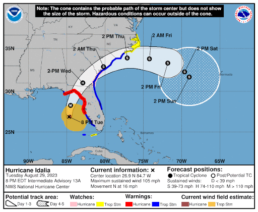
Weather in “The Neighborhood”.
August 29, 2023 8 Comments
Tropical Depression Eleven
Position: 28.2N 52.4W [10:00PM CDT 0300 UTC].
Movement: West-Northwest [285°] near 2 mph [ 4 kph].
Maximum sustained winds: 35 mph [ 55 kph].
Wind Gusts: 45 mph [ 70 kph].
Tropical Storm Wind Radius: 70 miles [110 km].
Hurricane Wind Radius: 15 miles [ 30 km].
Minimum central pressure: 1014 mb ↑.
Currently about 790 miles [1275 km] East-Southeast of the Bermuda.
Here’s the link for NOAA’s latest satellite images.
[For the latest information click on the storm symbol, or go to the CATEGORIES drop-down box below the CALENDAR and select “Hurricanes” for all of the posts related to storms on this site.]
August 29, 2023 Comments Off on Tropical Depression Eleven
Hurricane Idalia – Day 4
Position: 27.7N 84.5W [10:00PM CDT 0300 UTC].
Movement: North [010°] near 18 mph [30 kph].
Maximum sustained winds: 110 mph [170 kph].
Wind Gusts: 125 mph [200 kph].
Tropical Storm Wind Radius: 160 miles (260 km].
Hurricane Wind Radius: 25 miles [ 35 km].
Minimum central pressure: 958 mb ↓.
Currently about 125 miles [ 200 km] West of Tampa, Florida.
Currently about 225 miles [ 365 km] Southeast of Cinco Bayou, Florida.
A Hurricane Warning is in effect for the Middle of Longboat Key northward to the Indian Pass, including Tampa Bay.
A Tropical Storm Warning is in effect for Chokoloskee northward to the Middle of Longboat Key, and from west of the Indian Pass westward to Mexico Beach; Sebastian Inlet, Florida to South Santee River, South Carolina.
A Storm Surge Warning is in effect from Englewood northward to the Indian Pass, including Tampa Bay.
A Hurricane Watch is in effect for Mouth of the St. Mary’s River to Edisto Beach, South Carolina.
A Tropical Storm Watch is in effect for North of Surf City, North Carolina to the North Carolina/Virginia
border; Pamlico and Albemarle Sounds.
A Storm Surge Watch is in effect for Bonita Beach northward to Englewood, including Charlotte Harbour; Mouth of the St. Mary’s River to South Santee River, South Carolina; Beaufort Inlet to Drum Inlet, North Carolina; Neuse and Pamlico Rivers, North Carolina.
Here’s the link for NOAA’s latest satellite images.
[For the latest information click on the storm symbol, or go to the CATEGORIES drop-down box below the CALENDAR and select “Hurricanes” for all of the posts related to storms on this site.]
August 29, 2023 Comments Off on Hurricane Idalia – Day 4
Hurricane Franklin – Day 10
 Position: 32.3N 69.8W [10:00PM CDT 0300 UTC].
Movement: Northeast [040°] near 12 mph [19 kph].
Maximum sustained winds: 115 mph [185 kph].
Wind Gusts: 135 mph [215 kph].
Tropical Storm Wind Radius: 150 miles [240 km].
Hurricane Wind Radius: 35 miles [ 55 km].
Minimum central pressure: 953 mb ↑.
Currently about 245 miles [ 395 km] West of Bermuda.
A Tropical Storm Warning is in effect for the Bermuda.
Here’s the link for NOAA’s latest satellite images.
[For the latest information click on the storm symbol, or go to the CATEGORIES drop-down box below the CALENDAR and select “Hurricanes” for all of the posts related to storms on this site.]
August 29, 2023 Comments Off on Hurricane Franklin – Day 10
Katrina

It wasn’t the storm, it was the levees.
It wasn’t Nature, it was man.
August 29, 2023 Comments Off on Katrina
Tropical Storm Idalia – Day 3
Position: 22.0N 85.0W [10:00PM CDT 0300 UTC].
Movement: North [010°] near 8 mph [13 kph].
Maximum sustained winds: 70 mph [110 kph].
Wind Gusts: 80 mph [130 kph].
Tropical Storm Wind Radius: 150 miles (240 km].
Minimum central pressure: 983 mb.
Currently about 10 miles [ 15 km] Northwest of the western tip of Cuba.
A Hurricane Warning is in effect for extreme western Cuba for the province of Pinar Del Rio; the Middle of Longboat Key northward to the Indian Pass, including Tampa Bay.
A Tropical Storm Warning is in effect for the Yucatan Peninsula of Mexico from Tulum to Rio Lagartos, including Cozumel; the Isle of Youth, Cuba; Dry Tortugas, Florida; Chokoloskee northward to the Middle of Longboat Key, and from west of the Indian Pass westward to Mexico Beach; Sebastian Inlet, Florida to Altamaha Sound, Georgia.
A Storm Surge Warning is in effect from Englewood northward to the Indian Pass, including Tampa Bay.
A Hurricane Watch is in effect for Englewood to the Middle of Longboat Key.
A Tropical Storm Watch is in effect for Lower Florida Keys west of the west end of the Seven Mile Bridge; Sebastian Inlet, Florida northward to South Santee Rivera, South Carolina.
A Storm Surge Watch is in effect for Chokoloskee northward to Englewood, including Charlotte Harbour; Mouth of the St. Mary’s River to South Santee Rivera, South Carolina.
Here’s the link for NOAA’s latest satellite images.
[For the latest information click on the storm symbol, or go to the CATEGORIES drop-down box below the CALENDAR and select “Hurricanes” for all of the posts related to storms on this site.]
August 28, 2023 Comments Off on Tropical Storm Idalia – Day 3
Hurricane Franklin – Day 9
 Position: 29.4N 71.0W [10:00PM CDT 0300 UTC].
Movement: North [360°] near 9 mph [15 kph].
Maximum sustained winds: 150 mph [240 kph].
Wind Gusts: 165 mph [265 kph].
Tropical Storm Wind Radius: 150 miles [240 km].
Hurricane Wind Radius: 35 miles [ 55 km].
Minimum central pressure: 926 mb.
Currently about 420 miles [ 675 km] West-Southwest of Bermuda.
Franklin became the first major storm of the season (>= 115 mph) at 4AM CDT with a wind speed of 115, and then jumped to Category 4 with a speed of 145 at 8AM.
A Tropical Storm Watch is in effect for Bermuda.
Here’s the link for NOAA’s latest satellite images.
[For the latest information click on the storm symbol, or go to the CATEGORIES drop-down box below the CALENDAR and select “Hurricanes” for all of the posts related to storms on this site.]
August 28, 2023 Comments Off on Hurricane Franklin – Day 9


