
Idalia Map
Weather in “The Neighborhood”.
August 29, 2023 8 Comments
Tropical Depression Eleven
 Position: 28.2N 52.4W [10:00PM CDT 0300 UTC].
Movement: West-Northwest [285°] near 2 mph [ 4 kph].
Maximum sustained winds: 35 mph [ 55 kph].
Wind Gusts: 45 mph [ 70 kph].
Tropical Storm Wind Radius: 70 miles [110 km].
Hurricane Wind Radius: 15 miles [ 30 km].
Minimum central pressure: 1014 mb ↑.
Currently about 790 miles [1275 km] East-Southeast of the Bermuda.
Here’s the link for NOAA’s latest satellite images.
[For the latest information click on the storm symbol, or go to the CATEGORIES drop-down box below the CALENDAR and select “Hurricanes” for all of the posts related to storms on this site.]
August 29, 2023 Comments Off on Tropical Depression Eleven
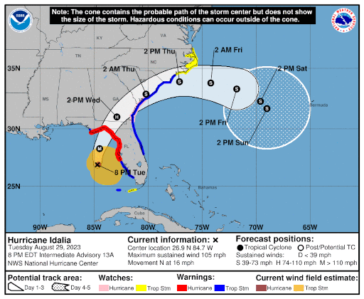
Hurricane Idalia – Day 4
 Position: 27.7N 84.5W [10:00PM CDT 0300 UTC].
Movement: North [010°] near 18 mph [30 kph].
Maximum sustained winds: 110 mph [170 kph].
Wind Gusts: 125 mph [200 kph].
Tropical Storm Wind Radius: 160 miles (260 km].
Hurricane Wind Radius: 25 miles [ 35 km].
Minimum central pressure: 958 mb ↓.
Currently about 125 miles [ 200 km] West of Tampa, Florida.
Currently about 225 miles [ 365 km] Southeast of Cinco Bayou, Florida.
A Hurricane Warning is in effect for the Middle of Longboat Key northward to the Indian Pass, including Tampa Bay.
A Tropical Storm Warning is in effect for Chokoloskee northward to the Middle of Longboat Key, and from west of the Indian Pass westward to Mexico Beach; Sebastian Inlet, Florida to South Santee River, South Carolina.
A Storm Surge Warning is in effect from Englewood northward to the Indian Pass, including Tampa Bay.
A Hurricane Watch is in effect for Mouth of the St. Mary’s River to Edisto Beach, South Carolina.
A Tropical Storm Watch is in effect for North of Surf City, North Carolina to the North Carolina/Virginia
border; Pamlico and Albemarle Sounds.
A Storm Surge Watch is in effect for Bonita Beach northward to Englewood, including Charlotte Harbour; Mouth of the St. Mary’s River to South Santee River, South Carolina; Beaufort Inlet to Drum Inlet, North Carolina; Neuse and Pamlico Rivers, North Carolina.
Here’s the link for NOAA’s latest satellite images.
[For the latest information click on the storm symbol, or go to the CATEGORIES drop-down box below the CALENDAR and select “Hurricanes” for all of the posts related to storms on this site.]
August 29, 2023 Comments Off on Hurricane Idalia – Day 4
Hurricane Franklin – Day 10
 Position: 32.3N 69.8W [10:00PM CDT 0300 UTC].
Movement: Northeast [040°] near 12 mph [19 kph].
Maximum sustained winds: 115 mph [185 kph].
Wind Gusts: 135 mph [215 kph].
Tropical Storm Wind Radius: 150 miles [240 km].
Hurricane Wind Radius: 35 miles [ 55 km].
Minimum central pressure: 953 mb ↑.
Currently about 245 miles [ 395 km] West of Bermuda.
A Tropical Storm Warning is in effect for the Bermuda.
Here’s the link for NOAA’s latest satellite images.
[For the latest information click on the storm symbol, or go to the CATEGORIES drop-down box below the CALENDAR and select “Hurricanes” for all of the posts related to storms on this site.]
August 29, 2023 Comments Off on Hurricane Franklin – Day 10
Katrina

It wasn’t the storm, it was the levees.
It wasn’t Nature, it was man.
August 29, 2023 Comments Off on Katrina


