
My Neighbors
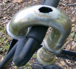
This is the trap I replaced, you know, the one belonging to the neighbor who couldn’t figure out where the water under the sink was coming from.
September 3, 2009 10 Comments
The Arctic Is Warming When It Should Be Cooling
In McClatchy the announcement of a new Study: Warming Arctic, after 1,900 years of cooling, isn’t natural
WASHINGTON — The Arctic was cooling for 1,900 years because of a natural change in Earth’s orbit until greenhouse gas accumulation from the use of fossil fuels reversed the trend in recent decades, according to a study published Thursday in Science magazine.
Scientists reconstructed the temperature record of the past 2,000 years using evidence from tree rings, ice cores and lake sediment, and found a steady cooling trend in Arctic summer temperatures of about 0.5 degrees Celsius — 0.9 degrees Fahrenheit — during the first 1,900 years. The cooling was caused by a slow natural cycle in Earth orbit that continues in this century.
“The summer cooling would likely be continuing today were it not for the increase of greenhouse gases from fossil fuel burning,” said David Schneider, a scientist at the National Center for Atmospheric Research and one of the authors of the study. “The results are important in showing that the dramatic changes happening today — and particularly the rapidity of the changes — are not natural.”
There is a 21,000 year cycle of change to the Earth’s temperature that is caused by the planet’s orbit. We are currently in the segment of the cycle that should be causing the planet to cool off, the segment that caused the Ice Ages. Not only are we not cooling, the temperatures in the Arctic are rising and have been for a while. It’s not just that we are warmer than “average”, the “average” should have been falling.
September 3, 2009 6 Comments
Station Fire Update 9-3
 Update from KTLA:
LA CANADA FLINTRIDGE — Forest Service officials say they have determined that the Station Fire was caused by arson.
As a result, L.A. County Sheriff’s Department has initiated homicide investigation.
Fire crews located the point of origin in the deadly blaze on Wednesday and that the area is being investigated as a crime scene.
The ignition point has only been identified as mile marker 29 on Angeles Crest Highway, about 2 miles from La Canada Flintridge.
The fire in the Angeles National Forest has now burned over 144,743 acres and at least 64 homes, three commercial buildings and 49 outbuildings. The cost estimate is $27 million. It is 38% contained.
The Station Fire was started off Angeles Crest Highway (SR 2) about one mile above Angeles Crest Fire Station around 3:30pm [PDT] Wednesday August 26, 2009.
Two Los Angeles County firefighters have died in a motor vehicle accident escaping a burnover. In addition there have been 7 others injured.
Currently there are 44 hand crews, 399 engines, 43 water tenders, 48 dozers, 8 air tankers, 13 helicopters, and 4,735 total personnel assigned to the fire.
The aircraft now include the 747 Supertanker [20,000 gallons], Tanker 910 [DC-10 12,000 gallons], Mars Hawaii Superscooper [7,200 gallons], and two Canadair 415 water scoopers [1,600 gallons] from the Province of Quebec.
Links: InciWeb, LA Times, KTLA, and Pasadena Star-News
Maps: LA Times fire map, the Enplan Wildfire Viewer, and the Weather Underground Smoke Map.
[For more information go to the CATEGORIES drop-down box below the CALENDAR and select “Fires” for all of the posts related to wildfires on this site.]
September 3, 2009 2 Comments
Tropical Depression Erika 9-3
 Position: 16.8 N 65.6 W [10 PM 0300 UTC].
Movement: West [280°] near 7 mph [11 kph].
Maximum sustained winds: 30 mph [50 kph].
Wind Gusts: 40 mph [65 kph].
Minimum central pressure: 1009 mb ↑.
It is 115 miles [185 km] South-Southeast of San Juan Puerto Rico.
It is now a remnant low, and this is the final advisory. Erika could never get it together and found all of the available wind shear in the area.
Here’s the link for NOAA’s latest satellite images.
[For the latest information click on the storm symbol, or go to the CATEGORIES drop-down box below the CALENDAR and select “Hurricanes” for all of the posts related to storms on this site.]
September 3, 2009 Comments Off on Tropical Depression Erika 9-3
Pacific Tropical Storm Jimena 9-3
 Position: 27.5 N 111.7 W [10 PM CDT 0300 UTC].
Movement: East-Southeast [120°] near 1 mph [2 kph].
Maximum sustained winds: 40 mph [65 kph].
Wind Gusts: 50 mph [80 kph].
Tropical Storm Wind Radius: 70 miles [110 km].
Minimum central pressure: 1004 mb ↑.
It is 40 miles [65 km] East-Northeast of Santa Rosalia Mexico.
The storm is over the Gulf of California/Sea of Cortez just off the East coast of Baja.
Here’s the link for NOAA’s latest satellite images.
[For the latest information click on the storm symbol, or go to the CATEGORIES drop-down box below the CALENDAR and select “Hurricanes” for all of the posts related to storms on this site.]
September 3, 2009 Comments Off on Pacific Tropical Storm Jimena 9-3


