Tropical Storm Ian – Day 3
 Position: 17.3N 81.4W [10:00PM CDT 0300UTC].
Movement: Northwest [315°] near 13 mph [20 kph].
Maximum sustained winds: 65 mph [100 kph].
Wind Gusts: 80 mph [130 kph].
Tropical Storm Wind Radius: 70 miles [110 km].
Minimum central pressure: 989 mb ↓.
Currently about 140 miles [ 225 km] South of Grand Cayman.
A Hurricane Warning is in effect for Grand Cayman; the Cuban provinces of Isla de Juventud, Pinar del Rio, and Artemisa.
A Tropical Storm Warning is in effect for the Cuban provinces of La Habana, Mayabeque, and Matanzas; Seven Mile Bridge southward to Key West, including the Dry Tortugas.
A Tropical Storm Watch is in effect for Little Cayman and Cayman Brac; Englewood southward to Chokoloskee.
A Storm Surge Watch is in effect for the Florida Keys from the Card Sound Bridge westward to Key West; Dry Tortugas; the West coast of Florida from Englewood southward to the Card Sound Bridge; Florida Bay.
Here’s the link for NOAA’s latest satellite images.
[For the latest information click on the storm symbol, or go to the CATEGORIES drop-down box below the CALENDAR and select “Hurricanes” for all of the posts related to storms on this site.]
September 25, 2022 Comments Off on Tropical Storm Ian – Day 3
Post-Tropical Cyclone Gaston – Day 6
 Position: 38.6N 38.2W [10:00PM CDT 0300UTC].
Movement: West-Southwest [245°] near 9 mph [15 kph].
Maximum sustained winds: 40 mph [ 65 kph].
Wind Gusts: 50 mph [ 80 kph].
Tropical Storm Wind Radius: 70 miles (110 km].
Minimum central pressure: 1005 mb ↑.
Currently about 510 miles [ 825 km] West of Faial Island in the central Azores.
This is the last public advisory issued by the National Hurricane Center on this system.
Here’s the link for NOAA’s latest satellite images.
[For the latest information click on the storm symbol, or go to the CATEGORIES drop-down box below the CALENDAR and select “Hurricanes” for all of the posts related to storms on this site.]
September 25, 2022 Comments Off on Post-Tropical Cyclone Gaston – Day 6
Post-Tropical Cyclone Hermine – Day 3
 Position: 23.6N 20.2W [ 4:00AM CDT 0900 UTC].
Movement: North [010°] near 7 mph [11 kph].
Maximum sustained winds: 30 mph [ 45 kph].
Wind Gusts: 40 mph [ 65 kph].
Minimum central pressure: 1008 mb ↑.
Currently about 580 miles [ 935 km] North-Northeast of the Cabo Verde Islands.
This is the last public advisory issued by the National Hurricane Center on Hermine.
Here’s the link for NOAA’s latest satellite images.
[For the latest information click on the storm symbol, or go to the CATEGORIES drop-down box below the CALENDAR and select “Hurricanes” for all of the posts related to storms on this site.]
September 25, 2022 Comments Off on Post-Tropical Cyclone Hermine – Day 3
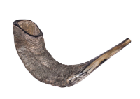
L’shanah Tovah
Happy 5783!
At sunset Rosh Hashanah [רֹאשׁ הַשָּׁנָה] begins, so get your honey, challah, and apples ready.
September 25, 2022 Comments Off on L’shanah Tovah


