
Tropical Depression Eleven
 Position: 17.2N 35.6W [10:00PM CDT 0300UTC].
Movement: North-Northwest [345°] near 10 mph [17 kph].
Maximum sustained winds: 35 mph [ 55 kph].
Wind Gusts: 45 mph [ 70 kph].
Minimum central pressure: 1008.
Currently about 770 miles [1240 km] West of the Cabo Verde Islands.
Here’s the link for NOAA’s latest satellite images.
[For the latest information click on the storm symbol, or go to the CATEGORIES drop-down box below the CALENDAR and select “Hurricanes” for all of the posts related to storms on this site.]
September 28, 2022 Comments Off on Tropical Depression Eleven
Ian Wind Field 9/28
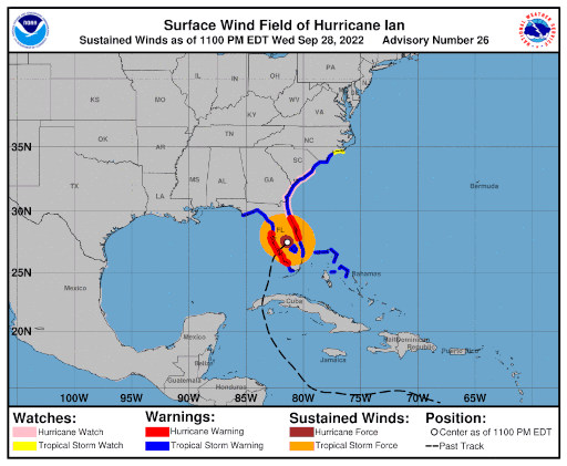
September 28, 2022 Comments Off on Ian Wind Field 9/28
Hurricane Ian – Day 6
 Position: 27.5N 81.4W [10:00PM [CDT 0300UTC].
Movement: North-Northeast [030°] near 8 mph [13 kph].
Maximum sustained winds: 90 mph [150 kph].
Wind Gusts: 105 mph [170 kph].
Tropical Storm Wind Radius: 175 miles [280 km].
Hurricane Wind Radius: 45 miles [ 75 km].
Minimum central pressure: 972 mb ↑.
Currently about 70 miles [ 150 km] South of Orlando, Florida.
Currently about 80 miles [ 110 km] Southwest of Cape Canaveral, Florida.
At 3:35PM CDT Ian made landfall between Fort Myers and Punta Gorda as a Category 4 storm with 145 mph sustained winds.
This is very bad for South Florida. A Category 4 landfall and the storm surge will be another Hurricane Andrew in effect.
A Hurricane Warning is in effect for Chokoloskee to the Anclote River, including Tampa Bay; Sebastian Inlet to Flagler/Volusia County Line.
A Tropical Storm Warning is in effect for Indian Pass to the Anclote River; Flamingo to Sebastian Inlet; Flamingo to Chokoloskee ;Flagler/Volusia County Line to Surf City; Lake Okeechobee; Bimini and Grand Bahama Islands.
A Storm Surge Warning is in effect for the Suwanee River southward to Flamingo; Tampa Bay; Flagler/Volusia Line to the mouth of the South Santee River; St. Johns River.
A Hurricane Watch is in effect for Flagler/Volusia County Line to the South Santee River.
A Tropical Storm Watch is in effect for North of Surf City to Cape Lookout.
A Storm Surge Watch is in effect for North of South Santee River to Little River Inlet.
Here’s the link for NOAA’s latest satellite images.
[For the latest information click on the storm symbol, or go to the CATEGORIES drop-down box below the CALENDAR and select “Hurricanes” for all of the posts related to storms on this site.]
September 28, 2022 Comments Off on Hurricane Ian – Day 6


