
Creative Cartography II
This an example of both Imperial Russian and Soviet mapping decisions.
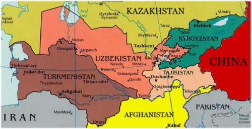
That corridor of Afghanistan that goes to China was a 19th century decision to separate Imperial Russia from British India, a “demilitarized zone” that prevented “locational errors” from forcing open warfare between two great powers, while they fought the “Great Game” with surrogates. All it really meant is that there were no “official armies” participating in the almost constant warfare in the area. This is the area that Rudyard Kipling was always using as a backdrop for his pieces set in India.
Head to the North and look at the way that Uzbekistan, Tajikistan, and Kyrgyzstan swirl together. That is an inspired piece of Soviet cartography intended to keep all three unhappy and at odds with each other. There is a valley where they meet that is a wonderful place with constant water, good soil, and a nice climate. Traditionally whichever of the three owned that valley controlled the other two and that lead to periods of relative peace, while the two out of the valley plotted to regain it.
The way things were arranged and the mountain ranges, the one who owns the largest portion of the valley, has to pass through one of the other two to get the produce out, and that eliminates any possibility of profit. In addition, the rivers that provide the water are not controlled by the main owner and occasionally get dammed. These things kept these peoples occupied during the Soviet period, rather than forming an alliance and causing trouble for the Soviet authorities, as they had for the Imperial Russian authorities.
The Uzbeks and Tajiks in Northern Afghanistan united long enough to help the US forces oust the Taliban, but they went back to their old warlord ways. When the Uzbek government cracked down on dissidents the Kyrgyz government gave them refuge. At some point, one of them is going to decide it has a chance to take the valley, and then there will be a war. It’s part of their heritage and now they have aircraft and tanks.


8 comments
Thanks for the history lesson. I have only recently (about 2001 or so) become interested in this Central Asian area, earlier having had no clue of its existence. I had thought the weird twistings of the boundaries were because of mountains or rivers, but to find out it was a deliberate method of creating long term stress is stunning.
Along with China beginning to hover over them and offering cheap and accessible goods, Russia eyeing them to see which way they’ll twitch, and everybody watching to see who will find more oil or build a pipeline, all these countries must be feeling a bit nervous.
Especially since the US stood up Georgia after egging them to attack Russia. Suddenly all our promises for beating off Russia and China while sending them US help doesn’t sound so good….
i didn’t know about that devilish little bit of cartography either. fascinating read.
The Tajiks have to go single file through the mountains to get to their bit, even though it looks like they are connected to the valley. If they need to get in with a truck, they have to go through Uzbekistan, or a pass in Kyrgyzstan through the mountains.
You may have heard of a guy name Tamerlane, or some variant of the spelling, who was Timur the Lame, an Uzbek. His descendants ruled India until the mid-19th century.
A lot of famous nastiness has started around the banks of the Amu Darya.
At one point, the (early) Soviets had a plan that would’ve resulted in a completely different creative cartograph than the one reproduced above. Early in the ’20s after the Civil War was over, Narkomnats (the People’s Commissariat for Nationalities, which is where Stalin hung out until he took over from Lenin in 1924) was slogging it out with Gosplan (the state economic planning agency) while the Bolsheviki tried to figure out just how they were going to set up their new state. Keeping to the old imperial lines didn’t seem to make much sense to them. Gosplan’s idea was to reorganize on economic lines: borders would be drawn to maximize the available natural and other resources for whatever the state planners decided would be produced in that particular region. Whereas Narkomnats, while not entirely opposed to the idea of maximizing economic potential, insisted that the nascent Soviet Union had to recognize (and grant what they called autonomy but which really wasn’t anything like it) all the various ethnic groups resident within the borders of the territory the Soviets controlled.
First the Party bureaucrats fought it out. Then the local bureaucrats fought it out. And in at least a few cases, actual people actually fought it out, over some of the less-popular and less-rational compromises arrived at between the two central planning agencies.
Fascinating stuff.
After they established the basic SSRs things get even stranger, and many of the oblasts contain none of the nationalities that are supposed to live there, the Jewish AO being the obvious one, but there were others, and mostly because there were exploitable resources know to be in the area. The later AOs tended to be economically worthless, and the groups stayed were they always lived, rather than starve in their new “homeland”.
The concept of a homeland didn’t make a lot of sense to the nomadic reindeer herders along the coast of the Arctic Ocean. I remember reading of a “first contact” with one of the tribes who had missed the Soviet era entirely. They had last had contact with the outside world with whalers during the 19th century and ran into a scientific team in 1995.
Initially the Jewish AO was going to be in the Ukraine, but the Ukrainian SSR refused to consider it, as did the Belarus, and the Russians still believed in the “pale”, so it was out to the Far East.
Didn’t work out so well for those that did go along, either. David Grant did an outstanding book a few years ago, called In the Soviet House of Culture. He worked with the Nivkhi on Sakhalin Island. The Soviets sold them a bill of goods about how things would be wonderful under Communism if they’d just give up their old ways. Most of them did, and at first, it went OK. Then the teachers started disappearing (and were replaced by people who made upwards of 30 grammatical errors in one paragraph of one of their official reports), and the native fisheries got pushed aside for ones owned and operated by Russians.
Now that the Soviet system has collapsed, these people don’t know what to do–they’re not Soviets anymore, but hardly anybody remembers what life was like or what they did before the Soviets came along. Never thought I’d ever read anybody wishing to go back to the “good old days” of Stalin!
The Russian and Japanese both over-fished the waters and destroyed any possibility of making it as a fisherman. In addition there were military installations strung out on Sakhalin and the Kyril Chain with a lot of nasty things leaking out into the soil on water from some of the weapons systems, and no one knows the effect from some the high-powered radars that were in use.
I have more than a passing familiarity with the area from the Kamchatka Peninsula down to Japan.
There are an amazing number of people who remember the Soviet era fondly, given the total screw-up that was the fall of the Soviet Union. I tried for a Peace Corp posting, but was rejected by both sides because of my “history”. I was recruited by a former DLI instructor who retired in this area, and was trying to help her little city, but apparently some restrictions are forever, no matter what they tell you at debriefing.
The problem for a lot of places was the total control of the transportation system. There are a lot of things like lumber that are in demand, but after the system broke down, there is no way of getting them from where they are to where they are wanted. The markets didn’t exist, and needed to be created first, before everything just shut down.
The guy who wrote the Tetris game was being paid royalties, but didn’t receive them because no one knew what to do with the checks that were being sent to the institution he worked at.
Capitalism like democracy requires some infrastructure, and the Soviet Union didn’t have it.
The thing about the Soviet system is that if you didn’t want to think or make decisions for yourself, life moved along. Having taken a few Russians for their first exposure to an American supermarket, I can tell you they go into shock because of the overload.
I started to write a comment on this, but it sort of got out of hand. I posted it over at my place.
http://johnmckay.blogspot.com/2008/08/creative-but-neglected-cartography.html