
Inquiring Minds Want To Know
Here’s a link to Katrina in the Weather Underground’s archive.
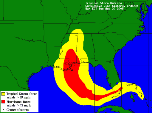
At 1PM CDT on August 28th Katrina was at 26.5 North 88.6 West with sustained winds of 175 mph and a central pressure of 902 mb, an all out Category 5 Hauptsturmfury with a 250 mile tropical storm wind radius and a 150 mile hurricane wind radius. It came ashore near the Pearl River affecting the Gulf Coast from Panama City, Florida to South of Lake Charles, Louisiana.
I’ve been getting a lot of Google searches for this.
Updated: I located the links to the National Hurricane Center advisories. They are in caps because they started out on the Teletype 33 terminals which only had capital letters.
I forgot to mention that two-thirds of the windfield is on the East side of the storm and the Northeast quadrant is where the strongest winds from the East, Southeast, and South are located.


12 comments
Keep safe. Keep dry. Keep posting updates.
Safe isn’t a problem, but I’m all wet from going after things I left in the trunk of the car.
…it’s horrible of me, I know, and I feel bad about it, but I am paying at least as much attention to Hanna. I’m scheduled to be putting my first-born on a plane Friday morning to fly back to college in Savannah and I’m having a bit of a problem with the concept of sending her off into the teeth of a possible hurricane landfall (I think the “How To Be A Parent” handbook has something in it about not doing this sort of thing)…
Of course, AirTran may solve the problem for me…
I wish I could help you out, Jack, but the models can’t figure it out. It is possible that after Gustav comes ashore and fades the steering models will start acting normally again, but right now the forecasters are frustrated by Hanna, and there are two Invests headed across the Atlantic to further muddy things up.
The only good news is that Hanna didn’t move close enough, about 900 miles, for the two storms to interact, because that situation generally boosts one or both of them.
She had to go to a school on the Atlantic Coast. She’s already seen the Pacific [we don’t have hurricanes] Coast. At least she didn’t choose New Orleans, Houston, or Miami.
At least she should own decent rain gear coming from Oregon, and tell her that only weirdo outsiders want to “experience” the wind and weather of a tropical event.
At the moment, and in the near term, it looks Hanna is just going to wobble around as a tropical storm.
Be safe, Bryan and all of you in or near the panhandle.
The storm is going to have more affect on you, than me, Steve. We have been having such rainy weather this summer, that this is not going to be much different.
Makes me realise how fortunate I am here on the southern coast of Aus. We don’t have events like this. I have lived up north in tropical storm and cyclone areas, and whilst in the mid east, we had a severe sand storm, so I have experienced some of mother nature at her worst. Once, in Sydney, there was a hail storm that killed a couple people and destroyed vehicles and damaged many buildings as the hail were the size of golf balls and coming down fast and hard (was almost like a mini-meteor shower).
Good luck all. Be smart, be safe.
Every area has something, Kryten. At least these things give you some warning, and after a while there is less work to do. Some of the things I did prior to Fay, I just left in place while I watched to see what Gustav would do, so there is less work every time.
We would get tornados and hail storms in Wichita Falls, Texas. It was a good way to get a car you couldn’t normally afford, if you didn’t mind some dings, but you didn’t go out in them unless you owned a helmet.
We appreciate the thoughts.
Bryan, it’s still uncertain whether Houston will get anything really bad. Near landfall, at least, hurricane-force winds are forecast no closer than High Island; we’re not liable to see the storm surge, and the primary danger to the city looks to be flooding in the middle of the week. Even so, the ground is nice and dry here lately. Of course there’s all that wandering around that Gustav may do once it crosses into Texas from Louisiana well north of here; some models show it swinging back southwest toward us. But no one here is evacuating, and the local forecast mainly shows a lot of rain.
This is another storm as peculiar as Fay. New Orleans is still the place apparently at greatest risk; I sincerely hope and pray everyone got out of there.
BTW, a good source of Houston info for anyone who needs it is SciGuy‘s Gustav Archives in the Houston Chronicle web site. SciGuy (Eric Berger, the Chronicle’s science editor) is an enthusiastic student of tropical weather, and he writes well.
I was thinking more of the rain, and proximity, Steve.
The outer bands are just starting to kick in, and the wind is getting a little gusty.
I heard on our news this morning that they were evacuating NO. So it’s even making news here and there are a lot of well wishers.
I really hope everyone makes it OK. Good luck everyone.
Cheers!
Paul.
They got out, the question is whether anything will be above water when they return.
So far only some sloshing over the tops of the levees.