Petroleumville Update

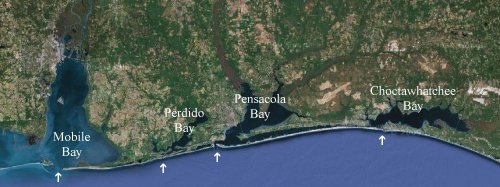
That is a satellite composite of the Alabama-Florida Gulf Coast with the bays named and the passes to the Gulf indicated with the arrows. The Perdido River and Bay constitute the western border of Florida. To give you an idea of the scale, it is forty miles from the pass of Choctawhatchee Bay west to the pass into Pensacola Bay. The western two-thirds of the barrier island between the passes is called Santa Rosa Island, and Okaloosa Island on the eastern end.
The island to the west of Pensacola Pass is Perdido Key, and it is split between Florida and Alabama so the Flora-Bama Lounge can hold its Interstate Mullet Toss.
The last barrier island is Dauphin Island west of the pass into Mobile Bay.
From the picture you can see that securing Mobile Bay poses a problem, but the Unified Command couldn’t stop it from entering Perdido Pass which is narrow and has a bridge in place to anchor the boom. The lack of proactive measures to prevent damage is driving people up the wall.
Via Mustang Bobby who gets up and blogs before sunrise in the Eastern Time Zone, the BP Spills Coffee which would be better with British and Texas accents [if they were real].


