Fickle Fay Fades
As I assumed at the 7 PM update, Fay has been downgraded to a tropical depression:
Position: 30.9 N 87.1 W. [10 PM CDT]
Movement: West-Northwest [285°] near 8 mph.
Maximum sustained winds: 35 mph.
Wind Gusts: 45 mph.
Minimum central pressure: 999 mb.
It is 30 miles North-Northeast of Pensacola, Florida, but looking at the regional radar, it would appear that Houston, Texas may get more in the way of “interesting weather” than I will [Sorry, Steve].
The rain bands are arching over the top and fading in Gulf.
This storm is just weird!
August 23, 2008 6 Comments
Tropical Storm Fay – Day 9
 Position: 30.7 N 86.7 W. [ 7 PM CDT]
Movement: West-Northwest [285°] near 7 mph.
Maximum sustained winds: 40 mph.
Wind Gusts: 55 mph.
Tropical Storm Wind Radius: 90 miles.
Minimum central pressure: 999 mb.
It is 35 miles Northeast of Pensacola, Florida.
It is North of I-10, North-Northwest of me, and may be downgraded in the next advisory, so I can start watching Invest 94L.
August 23, 2008 16 Comments
Creative Cartography I

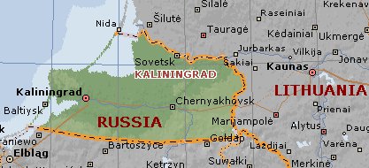
This is a map of the Kaliningrad Oblast of Russia. This area is where my family name comes from, but it was called Prussia when my great grandfather left in the 19th century to find his fortune and his wife in Berlin, before coming to the US. He spoke both Prussian, which was a Baltic language, and German.
As a result of World War II the area became part of the Soviet Union, and was assigned to the Russian SFSR.
August 23, 2008 4 Comments


